IMAGES TAKEN NEAR TO
Cockshut Road, LEWES, BN7 3PR
Introduction
This page details the photographs taken nearby to Cockshut Road, BN7 3PR by members of the Geograph project.
The Geograph project started in 2005 with the aim of publishing, organising and preserving representative images for every square kilometre of Great Britain, Ireland and the Isle of Man.

There are currently over 7.5m images from over14,400 individuals and you can help contribute to the project by visiting https://www.geograph.org.uk
Image Map
Images are licensed for reuse under creativecommons.org/licenses/by-sa/2.0
Notes
- Clicking on the map will re-center to the selected point.
- The higher the marker number, the further away the image location is from the centre of the postcode.
Image Listing (25 Images Found)
Images are licensed for reuse under creativecommons.org/licenses/by-sa/2.0
Image
Details
Distance
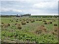
1
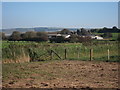
Rise Farm
A farm sitting on The Brooks. The area to the foreground is Lewes Brooks RSPB nature reserve.
Image: © Oast House Archive
Taken: 27 Sep 2011
0.01 miles
2
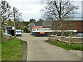
Rise Farm
Little if any proper farm activity now, that seems to be based at Iford. Instead, a few businesses are based here.
Image: © Robin Webster
Taken: 29 Apr 2021
0.01 miles
3
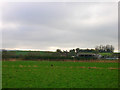
Rise Farm and Upper Rise, Lewes
In the Ouse flood plain south of Lewes there are two small rises, the Upper and Lower Rise. Both are farmed from Rise Farm. This view takes in the farm and the Upper Rise. Unfortunately, there is no public access beyond this point, hence the distant shot. This looks south from the farm track next to the bypass.
Image: © Simon Carey
Taken: 13 Nov 2005
0.02 miles
4
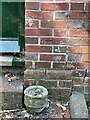
Cut Mark on Rise Farm Cottages
This cut mark on the right of a doorway is described in https://www.bench-marks.org.uk/bm174825. See https://www.geograph.org.uk/photo/7258407 for a wider view of the building.
Image: © Brian Westlake
Taken: 13 Aug 2022
0.03 miles
5

Rise Farm Cottages
On the right of the doorway is a cut bench mark described at https://www.bench-marks.org.uk/bm174825. See https://www.geograph.org.uk/photo/7258406 for a close-up.
Image: © Brian Westlake
Taken: 13 Aug 2022
0.03 miles
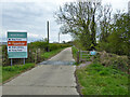
6
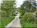
Down the rise to Rise Farm
A private road, permissive footpath.
Image: © Robin Webster
Taken: 29 Apr 2021
0.03 miles
7
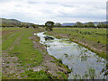
Recently cleaned ditch, Lewes Brooks
Large parts of these levels, including this bit, are a Site of Special Scientific Interest (SSSI).
Image: © Robin Webster
Taken: 29 Apr 2021
0.13 miles
8
View across Lewes Brooks towards Rise Farm
Large parts of these levels, including this bit, are a Site of Special Scientific Interest (SSSI).
Image: © Robin Webster
Taken: 29 Apr 2021
0.13 miles
9
Upper Rise
One of two islands of high ground rising above the level of Lewes Brooks, this one further north than Lower Rise.
Image: © Robin Webster
Taken: 6 Sep 2014
0.13 miles
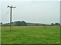
10
Road to Rise Farm
The important notice for walkers is on the right: 'Permissive footpath only No public right of way'. This hardly publicised and unmapped path extends beyond the farm over the fields to Iford.
Image: © Robin Webster
Taken: 29 Apr 2021
0.16 miles