IMAGES TAKEN NEAR TO
St. Pancras Green, LEWES, BN7 3LH
Introduction
This page details the photographs taken nearby to St. Pancras Green, BN7 3LH by members of the Geograph project.
The Geograph project started in 2005 with the aim of publishing, organising and preserving representative images for every square kilometre of Great Britain, Ireland and the Isle of Man.

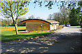
There are currently over 7.5m images from over14,400 individuals and you can help contribute to the project by visiting https://www.geograph.org.uk
Image Map
Images are licensed for reuse under creativecommons.org/licenses/by-sa/2.0
Notes
- Clicking on the map will re-center to the selected point.
- The higher the marker number, the further away the image location is from the centre of the postcode.
Image Listing (166 Images Found)
Images are licensed for reuse under creativecommons.org/licenses/by-sa/2.0
Image
Details
Distance
1
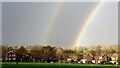
View north over the recreation ground - with double rainbow
When I look at this photograph I keep fancying I see an extremely faint third rainbow. It's probably my imagination, since triple rainbows are very rare.
Image: © Ian Hawfinch
Taken: 15 Nov 2020
0.02 miles
2
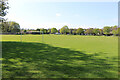
St Pancras Green, Kingston, East Sussex
Situated close to St Pancras Church, St Pancras Green is used for sports and community events.
Image: © Andrew Diack
Taken: 24 Apr 2022
0.03 miles
3
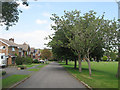
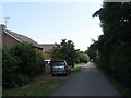
St Pancras Green
Housing estate built in the 1960s next to the recreation ground that bears the same name. Viewed from Church Lane.
Image: © Simon Carey
Taken: 10 Aug 2012
0.03 miles
4
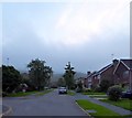
Lockitt Way, Kingston near Lewes
Built in the 1960s and located off The Avenue. Kingston Hill beyond is obscured by low cloud.
Image: © Simon Carey
Taken: 19 Aug 2018
0.05 miles
5
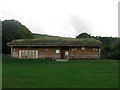
New sports pavilion, Kingston near Lewes
A replacement for a smaller elderly structure on the same site, it may still be in the final stages of fitting out.
Image: © Robin Webster
Taken: 24 Apr 2010
0.05 miles
6
Kingston Community Pavilion
Recently rebuilt sporting pavilion on the north western edge of St Pancras Green, the village recreation ground. Comes with an eco-friendly roof.
Image: © Simon Carey
Taken: 12 Aug 2012
0.06 miles
7
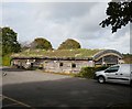
Kingston near Lewes: the Community Pavilion, with 'green' roof
A local resident told me that the grass had been mown fairly recently, and had been a good deal longer back in summer.
The pavilion overlooks a sizeable green.
Image: © Stefan Czapski
Taken: 10 Oct 2019
0.06 miles
8
Church Lane
The houses date from the 1960s and were built next to a track that was made in the mid 19th century after the old open fields were enclosed.
Image: © Simon Carey
Taken: 10 Aug 2012
0.06 miles
10
Kingston near Lewes
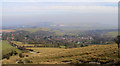
Until the 1920s Kingston was just a small village of one street with a few houses, one school, one pub and one church. Since then it has expanded considerably attracting lecturers from the nearby Sussex University at Falmer. The lane to the left is Kingston Ridge. The county town of Lewes can be seen on the left with Malling Hill Image towards the centre and Mount Caburn Image on the right.
Image: © Kevin Gordon
Taken: 31 Jan 2009
0.07 miles