IMAGES TAKEN NEAR TO
Newhaven Road, LEWES, BN7 3HD
Introduction
This page details the photographs taken nearby to Newhaven Road, BN7 3HD by members of the Geograph project.
The Geograph project started in 2005 with the aim of publishing, organising and preserving representative images for every square kilometre of Great Britain, Ireland and the Isle of Man.

There are currently over 7.5m images from over14,400 individuals and you can help contribute to the project by visiting https://www.geograph.org.uk
Image Map
Images are licensed for reuse under creativecommons.org/licenses/by-sa/2.0
Notes
- Clicking on the map will re-center to the selected point.
- The higher the marker number, the further away the image location is from the centre of the postcode.
Image Listing (138 Images Found)
Images are licensed for reuse under creativecommons.org/licenses/by-sa/2.0
Image
Details
Distance
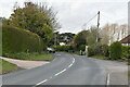
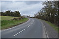
2
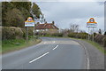
Newhaven Road
Once the A275 but downgraded and now known locally as the C7. The road is an old route linking the villages on the western side of the Ouse valley with Lewes to the north and Newhaven to the south. In the 1980s the route on the eastern side of the valley was upgraded to the A26 in order to take all heavy goods traffic away from this route and prevent it going through the narrow streets of Lewes.
Image: © Simon Carey
Taken: 26 Dec 2008
0.02 miles
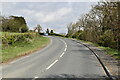
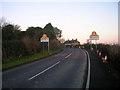
3
Newhaven Road
The C7 entering the village of Rodmell from the south. The road is an old one linking villages along the spring line on the sheltered western side of the Ouse valley and was the A275 until the 1970s when all traffic was rerouted along the newly designated A26 on the eastern side of the valley. The cottages beyond were built in the 1920s and were originally known as Council Cottages but have since been changed to Ouseside Cottages.
Image: © Simon Carey
Taken: 10 Aug 2012
0.02 miles
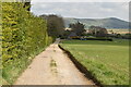
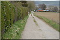
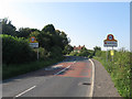
6
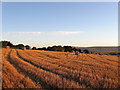
Slipe Laine (3)
Another view of Image about half an hour after sunrise taken from the permissive footpath that runs between Rodmell and Southease. See also Image
Image: © Simon Carey
Taken: 22 Sep 2012
0.06 miles