IMAGES TAKEN NEAR TO
Iford, LEWES, BN7 3ET
Introduction
This page details the photographs taken nearby to BN7 3ET by members of the Geograph project.
The Geograph project started in 2005 with the aim of publishing, organising and preserving representative images for every square kilometre of Great Britain, Ireland and the Isle of Man.

There are currently over 7.5m images from over14,400 individuals and you can help contribute to the project by visiting https://www.geograph.org.uk
Image Map
Images are licensed for reuse under creativecommons.org/licenses/by-sa/2.0
Notes
- Clicking on the map will re-center to the selected point.
- The higher the marker number, the further away the image location is from the centre of the postcode.
Image Listing (227 Images Found)
Images are licensed for reuse under creativecommons.org/licenses/by-sa/2.0
Image
Details
Distance
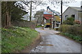
1
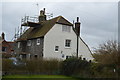
Shepherd's Cottage
Grade II listed. http://www.britishlistedbuildings.co.uk/en-414313-shepherds-cottages-iford-east-sussex
Image: © N Chadwick
Taken: 7 Apr 2016
0.01 miles
3
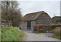
Barn, Iford Farm
Grade II listed. http://www.britishlistedbuildings.co.uk/en-414315-barn-to-the-east-of-no-1-lower-stall-cot
Image: © N Chadwick
Taken: 7 Apr 2016
0.03 miles
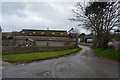
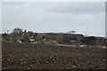
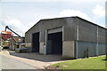
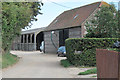
4
Iford Farm
More outbuildings for the local farm which covers most of the southern half of the village. The lane continues past the buildings then out onto The Brooks along Sutton Wall.
Image: © Simon Carey
Taken: 21 Sep 2008
0.03 miles
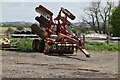
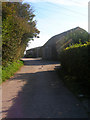
5
Barn at Iford Farm
A flint and brick barn with portal frame barn behind.
Image: © Oast House Archive
Taken: 1 Sep 2011
0.03 miles