IMAGES TAKEN NEAR TO
Crisp Road, LEWES, BN7 2TY
Introduction
This page details the photographs taken nearby to Crisp Road, BN7 2TY by members of the Geograph project.
The Geograph project started in 2005 with the aim of publishing, organising and preserving representative images for every square kilometre of Great Britain, Ireland and the Isle of Man.

There are currently over 7.5m images from over14,400 individuals and you can help contribute to the project by visiting https://www.geograph.org.uk
Image Map
Images are licensed for reuse under creativecommons.org/licenses/by-sa/2.0
Notes
- Clicking on the map will re-center to the selected point.
- The higher the marker number, the further away the image location is from the centre of the postcode.
Image Listing (32 Images Found)
Images are licensed for reuse under creativecommons.org/licenses/by-sa/2.0
Image
Details
Distance
1

The Ouse
The River Ouse with Offham chalk pit in the background
Image: © Peter Jeffery
Taken: 1 Sep 2000
0.10 miles
2
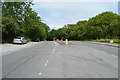
Landport Fork
Road junction where the A2029 meets the A275. In fact Offham Road is the name of the former and continues as the latter north of the junction. The road coming up from the south is Nevill Road. A motorcycle has been dumped next to the national speed limit sign.
Image: © Simon Carey
Taken: 29 Dec 2008
0.10 miles
3
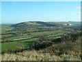
Malling Brooks near Lewes
River Ouse just north of Lewes looking south east from Offham Hill. The appearance of the river and lush grazing marshes make a delightful approach to the town when viewed from a window of the London to Lewes train.
Image: © David Saunders
Taken: 2 Jan 2005
0.11 miles
6
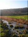
Landport Farm
Viewed from an unmarked path that connects the Landport Estate with the river, a frozen drainage ditch is in the foreground.
Image: © Simon Carey
Taken: 29 Dec 2008
0.18 miles
7
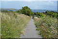
Greenwich Meridian in Papermill Cut meadow
This picture was taken standing on the Greenwich meridian looking South. The left half of the image is in the Eastern Hemisphere and the right is in the Western. The meridian passes straight through the middle, see this http://www.riddlerworld.co.uk/meridian/PG1127.htm for an alternate image with the meridian superimposed as a yellow line. The Meridian crosses Papermill Cut meadows between Lewes and the rail line.
Image: © steve ridley
Taken: 25 Mar 2011
0.18 miles
9

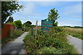
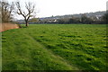
Private road and public footpath to the old Lewes racecourse
Also at the top of rise is the site of the Battle of Lewes in 1264.
Image: © Dave Spicer
Taken: 15 Mar 2012
0.19 miles