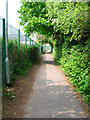
IMAGES TAKEN NEAR TO
Stansfield Road, LEWES, BN7 2SL
Introduction
This page details the photographs taken nearby to Stansfield Road, BN7 2SL by members of the Geograph project.
The Geograph project started in 2005 with the aim of publishing, organising and preserving representative images for every square kilometre of Great Britain, Ireland and the Isle of Man.

There are currently over 7.5m images from over14,400 individuals and you can help contribute to the project by visiting https://www.geograph.org.uk
Image Map
Images are licensed for reuse under creativecommons.org/licenses/by-sa/2.0
Notes
- Clicking on the map will re-center to the selected point.
- The higher the marker number, the further away the image location is from the centre of the postcode.
Image Listing (51 Images Found)
Images are licensed for reuse under creativecommons.org/licenses/by-sa/2.0
Image
Details
Distance
1
Landport Road
Originally a farm track connecting Landport Farm with Offham Road. On the building of the Landport estate it became a main thoroughfare but has now been blocked off at the southern end leaving this part as a path between Landport Recreation Ground and the grounds of Pells Primary School.
Image: © Simon Carey
Taken: 29 Apr 2007
0.04 miles
2
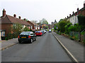
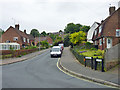
Stansfield Road
Part of the Landport estate which was built in the mid 1930s as a big council estate. Looking towards the junction with Landport Road.
Image: © Simon Carey
Taken: 29 Apr 2007
0.04 miles
3
Newton Road
Part of the Landport estate which lies between the railway and the A2029.
Image: © Simon Carey
Taken: 29 Apr 2007
0.07 miles
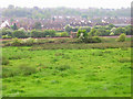
4
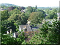
Viewpoint looking across to the site of the Battle of Lewes
An information plaque here explains that on 14th May 1264 Simon de Montford's army of 5,000 barons and Londoners defeated Royalist forces of twice that size under Henry III on the downs north-west of Lewes. The Mise of Lewes signed the next day led to the first English Parliament meeting at Westminster 20th January 1265. To see the information plaque go to http://www.geograph.org.uk/photo/3120820 and see also http://www.geograph.org.uk/photo/3120904
Image: © Marathon
Taken: 6 Sep 2012
0.08 miles
5
Stansfield Road, Lewes
A road on the Landport Estate, whose roads are largely laid out on a hexagonal pattern.
Image: © Robin Webster
Taken: 21 May 2014
0.09 miles
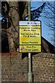
6
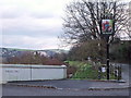
Pub sign in Kingsley Road, Lewes
The Tally Ho is actually below the sign in the Landport Eastate and can be accessed by the steps seen in the photo.
Image: © nick macneill
Taken: 11 Jan 2011
0.09 miles
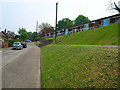
7
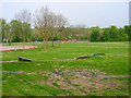
Landport Recreation Ground
Situated between the railway which can just be seen beyond the play equipment and Landport Road.
Image: © Simon Carey
Taken: 29 Apr 2007
0.10 miles
8
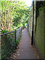
Footpath to The Pells
The wall to the right is part of Wallands Crescent and includes a recessed seat.
Image: © Simon Carey
Taken: 29 Apr 2007
0.10 miles
9
Railway Hut
On the Lewes-Keymer Junction line with the Landport estate beyond.
Image: © Simon Carey
Taken: 29 Apr 2007
0.14 miles
10
Athletes Only Cross Here!
A street sign seen in Offham Road, Lewes.
Image: © Peter Jeffery
Taken: 12 Feb 2018
0.15 miles