IMAGES TAKEN NEAR TO
Lee Road, LEWES, BN7 2SE
Introduction
This page details the photographs taken nearby to Lee Road, BN7 2SE by members of the Geograph project.
The Geograph project started in 2005 with the aim of publishing, organising and preserving representative images for every square kilometre of Great Britain, Ireland and the Isle of Man.

There are currently over 7.5m images from over14,400 individuals and you can help contribute to the project by visiting https://www.geograph.org.uk
Image Map
Images are licensed for reuse under creativecommons.org/licenses/by-sa/2.0
Notes
- Clicking on the map will re-center to the selected point.
- The higher the marker number, the further away the image location is from the centre of the postcode.
Image Listing (43 Images Found)
Images are licensed for reuse under creativecommons.org/licenses/by-sa/2.0
Image
Details
Distance
1
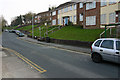
Stansfield Road, Lewes
A road on the Landport Estate, whose roads are largely laid out on a hexagonal pattern.
Image: © Robin Webster
Taken: 21 May 2014
0.02 miles
2
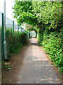
Landport Road
Originally a farm track connecting Landport Farm with Offham Road. On the building of the Landport estate it became a main thoroughfare but has now been blocked off at the southern end leaving this part as a path between Landport Recreation Ground and the grounds of Pells Primary School.
Image: © Simon Carey
Taken: 29 Apr 2007
0.07 miles
3
Pub sign in Kingsley Road, Lewes
The Tally Ho is actually below the sign in the Landport Eastate and can be accessed by the steps seen in the photo.
Image: © nick macneill
Taken: 11 Jan 2011
0.09 miles
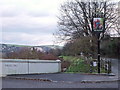
4
Railway Hut
On the Lewes-Keymer Junction line with the Landport estate beyond.
Image: © Simon Carey
Taken: 29 Apr 2007
0.11 miles
5
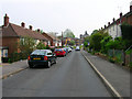
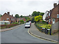
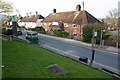
Stansfield Road
Part of the Landport estate which was built in the mid 1930s as a big council estate. Looking towards the junction with Landport Road.
Image: © Simon Carey
Taken: 29 Apr 2007
0.12 miles
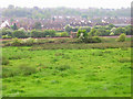
6
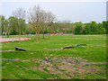
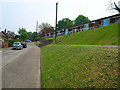
Landport Recreation Ground
Situated between the railway which can just be seen beyond the play equipment and Landport Road.
Image: © Simon Carey
Taken: 29 Apr 2007
0.13 miles
7
Greenwich Meridian crossing Offham Rd
This picture was taken standing on the Greenwich meridian looking South. The left half of the image is in the Eastern Hemisphere and the right is in the Western. The meridian passes straight through the middle, see this http://www.riddlerworld.co.uk/meridian/PG1073.htm for an alternate image with the meridian superimposed as a yellow line. This is where the Meridian crosses Offham Road and then Hill Road near the junction of the two.
Image: © steve ridley
Taken: 22 Mar 2011
0.15 miles
8
Greenwich meridian crossing Meridian Rd in Lewes
This picture was taken standing on the Greenwich meridian looking South. The left half of the image is in the Eastern Hemisphere and the right is in the Western. The meridian passes straight through the middle, see this http://www.riddlerworld.co.uk/meridian/PG1081.htm for an alternate image with the meridian superimposed as a yellow line. This is where the Airy meridian crosses Meridian Road in Lewes, The council have erected an obelisk on the Bradley meridian, just off the right hand side of this photo.
Image: © steve ridley
Taken: 25 Mar 2011
0.15 miles
9
Greenwich meridian obelisk in Meridian Road, Lewes
This picture was taken standing on the Greenwich meridian looking North. The Airy meridian crosses the road in the middle of this picture; see this http://www.riddlerworld.co.uk/meridian/PG1078.htm for an alternate image with the meridian superimposed as a yellow line. This is where the Airy meridian crosses Meridian Road in lewes, The council have erected an obelisk on the Bradley meridian which is on the right hand edge of this photo. See this http://www.thegreenwichmeridian.org/tgm/location.php?i_latitude=50.879559&i_type=
Image: © steve ridley
Taken: 25 Mar 2011
0.15 miles
10
Newton Road
Part of the Landport estate which lies between the railway and the A2029.
Image: © Simon Carey
Taken: 29 Apr 2007
0.15 miles