IMAGES TAKEN NEAR TO
Court Road, LEWES, BN7 2SA
Introduction
This page details the photographs taken nearby to Court Road, BN7 2SA by members of the Geograph project.
The Geograph project started in 2005 with the aim of publishing, organising and preserving representative images for every square kilometre of Great Britain, Ireland and the Isle of Man.

There are currently over 7.5m images from over14,400 individuals and you can help contribute to the project by visiting https://www.geograph.org.uk
Image Map
Images are licensed for reuse under creativecommons.org/licenses/by-sa/2.0
Notes
- Clicking on the map will re-center to the selected point.
- The higher the marker number, the further away the image location is from the centre of the postcode.
Image Listing (947 Images Found)
Images are licensed for reuse under creativecommons.org/licenses/by-sa/2.0
Image
Details
Distance
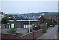
1
Former Railway Embankment
The start of the Lewes to Uckfield line now hidden in the Railway Land Nature Reserve. From the embankment it was carried on a viaduct over the original line to Hastings and Newhaven and Cliffe High Street.
Image: © Simon Carey
Taken: 7 Oct 2006
0.03 miles
2
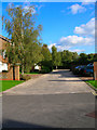
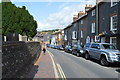
Court Road
New housing built in the 1990s on the former Lewes to Uckfield railway.
Image: © Simon Carey
Taken: 7 Oct 2006
0.03 miles
4
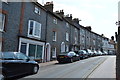
Houses, Friar's Walk
All are Grade II listed.
Image: © N Chadwick
Taken: 12 Jul 2015
0.05 miles
5
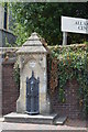
Fountain, Friars' Walk
Grade II listed. http://www.britishlistedbuildings.co.uk/en-293107-fountain-to-south-of-all-saints-church-l
Image: © N Chadwick
Taken: 12 Jul 2015
0.05 miles
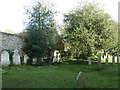
7
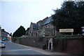
All Saints' Centre
Former parish church. Grade II* listed. http://www.britishlistedbuildings.co.uk/en-293101-all-saint-s-community-centre-lewes
Image: © N Chadwick
Taken: 14 Apr 2011
0.06 miles
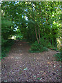
9
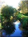
Winterbourne Stream
Taken from the point where the stream goes underground to avoid the station and railway. Now part of the Railway Land Nature Reserve.
Image: © Simon Carey
Taken: 7 Oct 2006
0.06 miles