IMAGES TAKEN NEAR TO
Malling Street, LEWES, BN7 2RH
Introduction
This page details the photographs taken nearby to Malling Street, BN7 2RH by members of the Geograph project.
The Geograph project started in 2005 with the aim of publishing, organising and preserving representative images for every square kilometre of Great Britain, Ireland and the Isle of Man.

There are currently over 7.5m images from over14,400 individuals and you can help contribute to the project by visiting https://www.geograph.org.uk
Image Map
Images are licensed for reuse under creativecommons.org/licenses/by-sa/2.0
Notes
- Clicking on the map will re-center to the selected point.
- The higher the marker number, the further away the image location is from the centre of the postcode.
Image Listing (491 Images Found)
Images are licensed for reuse under creativecommons.org/licenses/by-sa/2.0
Image
Details
Distance
1
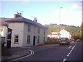
Junction of Thomas Street and Malling Street
Image: © David Howard
Taken: 12 Sep 2011
0.00 miles
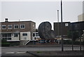
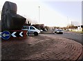
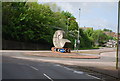
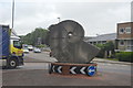
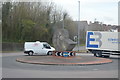
7
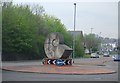
Ammonite Statue at the entrance to the Cuilfail Tunnel
Image: © N Chadwick
Taken: 29 Apr 2010
0.04 miles
8
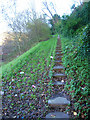
Steps to Undercliff House
A steep climb up the northern side of Chapel Hill. The sharp eyed among you may spot a cat running up them.
Image: © Simon Carey
Taken: 9 Dec 2006
0.05 miles
9
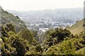
Lewes on a Hazy Day
Looking down Malling Combe.
Image: © Peter Jeffery
Taken: Unknown
0.05 miles
10
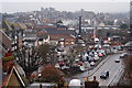
Lewes, Sussex
View over the town, in the direction of Lewes Castle. Harveys Brewery can be seen, in the middle of picture. Photograph taken from the road which leads to Cuilfail.
Image: © Peter Trimming
Taken: 29 Dec 2010
0.07 miles