IMAGES TAKEN NEAR TO
Queens Road, LEWES, BN7 2JQ
Introduction
This page details the photographs taken nearby to Queens Road, BN7 2JQ by members of the Geograph project.
The Geograph project started in 2005 with the aim of publishing, organising and preserving representative images for every square kilometre of Great Britain, Ireland and the Isle of Man.

There are currently over 7.5m images from over14,400 individuals and you can help contribute to the project by visiting https://www.geograph.org.uk
Image Map
Images are licensed for reuse under creativecommons.org/licenses/by-sa/2.0
Notes
- Clicking on the map will re-center to the selected point.
- The higher the marker number, the further away the image location is from the centre of the postcode.
Image Listing (20 Images Found)
Images are licensed for reuse under creativecommons.org/licenses/by-sa/2.0
Image
Details
Distance
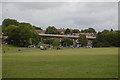
1

Sussex Police HQ Mast from Hamsey
Looking over the flood plains of the River Ouse which can just be seen on the right.
Image: © Kevin Gordon
Taken: 18 Oct 2008
0.04 miles
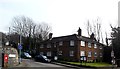
3
Malling House, Lewes
A C17th house refronted in the 1720s presenting an attractive face in red, grey and orange brick. It also has a fine Tuscan doorcase. The chimneystacks provided some vertical emphasis to counteract its predominant horizontality. Grade I listed.
The date of the photo is uncertain, but at the time this was used as offices by Sussex Police and in 2013 this still appears to be the case.
Image: © Stephen Richards
Taken: Unknown
0.13 miles
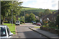
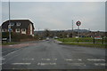
5
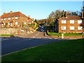
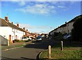
Mill Road, South Malling
Looking east from Church Lane through the junction with the A26.
Image: © Simon Carey
Taken: 13 Nov 2005
0.17 miles
7
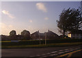
Sunset over Church Lane, South Malling
Image: © David Howard
Taken: 12 Sep 2011
0.19 miles
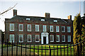
8

Lewes Castle
If one stood here on 14th May 1264, one would see the Battle of Lewes raging in front between Henry III and the rebel barons led by Simon de Montfort. Henry lost and sought refuge in the priory. Next day he signed the Mise of Lewes, which gave Simon de Montfort a lot of power over the king.
Image: © Michael Garlick
Taken: 12 Mar 2015
0.20 miles