IMAGES TAKEN NEAR TO
Malling Close, LEWES, BN7 2HU
Introduction
This page details the photographs taken nearby to Malling Close, BN7 2HU by members of the Geograph project.
The Geograph project started in 2005 with the aim of publishing, organising and preserving representative images for every square kilometre of Great Britain, Ireland and the Isle of Man.

There are currently over 7.5m images from over14,400 individuals and you can help contribute to the project by visiting https://www.geograph.org.uk
Image Map
Images are licensed for reuse under creativecommons.org/licenses/by-sa/2.0
Notes
- Clicking on the map will re-center to the selected point.
- The higher the marker number, the further away the image location is from the centre of the postcode.
Image Listing (50 Images Found)
Images are licensed for reuse under creativecommons.org/licenses/by-sa/2.0
Image
Details
Distance
3
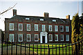
Malling House, Lewes
A C17th house refronted in the 1720s presenting an attractive face in red, grey and orange brick. It also has a fine Tuscan doorcase. The chimneystacks provided some vertical emphasis to counteract its predominant horizontality. Grade I listed.
The date of the photo is uncertain, but at the time this was used as offices by Sussex Police and in 2013 this still appears to be the case.
Image: © Stephen Richards
Taken: Unknown
0.09 miles
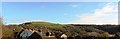
4

Sussex Police HQ Mast from Hamsey
Looking over the flood plains of the River Ouse which can just be seen on the right.
Image: © Kevin Gordon
Taken: 18 Oct 2008
0.10 miles
5
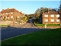
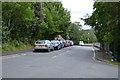
Mill Road, South Malling
Looking east from Church Lane through the junction with the A26.
Image: © Simon Carey
Taken: 13 Nov 2005
0.14 miles
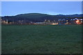
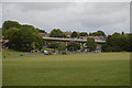
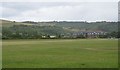
8
Malling Recreation Ground
Occupying much of the area once covered by Malling Brooks which has since been drained and mostly built over except for this green space wedged between South Malling, Tescos and the river. The village of South Malling can be seen at the far end of the recreation ground with Sussex Police's communications mast behind the houses.
Image: © Simon Carey
Taken: 29 Dec 2008
0.15 miles
9
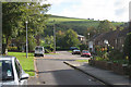
Over the rooftops to Malling Hill, Lewes
Image: © nick macneill
Taken: 9 Nov 2012
0.16 miles
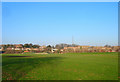
10
Playing fields by the River Ouse
South Malling Community Centre in view
Image: © N Chadwick
Taken: 12 Jul 2015
0.16 miles