IMAGES TAKEN NEAR TO
St. Nicholas Lane, LEWES, BN7 2GH
Introduction
This page details the photographs taken nearby to St. Nicholas Lane, BN7 2GH by members of the Geograph project.
The Geograph project started in 2005 with the aim of publishing, organising and preserving representative images for every square kilometre of Great Britain, Ireland and the Isle of Man.

There are currently over 7.5m images from over14,400 individuals and you can help contribute to the project by visiting https://www.geograph.org.uk
Image Map
Images are licensed for reuse under creativecommons.org/licenses/by-sa/2.0
Notes
- Clicking on the map will re-center to the selected point.
- The higher the marker number, the further away the image location is from the centre of the postcode.
Image Listing (1195 Images Found)
Images are licensed for reuse under creativecommons.org/licenses/by-sa/2.0
Image
Details
Distance
1
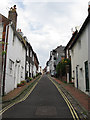
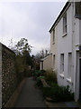
St Nicholas Lane
Another of the narrow medieval lanes that link the High Street to the site of the former town walls. The name commemorates a former church that once stood at the northern end that was merged with nearby All Saints during the 14th century and its remnants eventually pulled down in 1761.
Image: © Simon Carey
Taken: 19 Aug 2012
0.02 miles
2
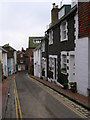
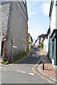
St Nicholas Lane
Running parallel with and to the east of Station Street. Looking towards the junction with Lansdowne Place (B2193).
Image: © Simon Carey
Taken: 4 Feb 2007
0.02 miles
4

In a Lewes flea-market, 1
Pots and stuff in the outer yard.
Image: © Jonathan Billinger
Taken: 8 Jul 2015
0.03 miles
5
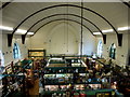
In a Lewes flea-market, 2
View from the balcony of this ex-church building.
Image: © Jonathan Billinger
Taken: 8 Jul 2015
0.03 miles
6
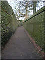
Walwers Lane
To the east of St Nicholas Lane and another ancient byway linking High Street with Friars Walk.
Image: © Simon Carey
Taken: 4 Feb 2007
0.03 miles
8
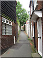
Church Twitten
Another ancient lane this one to the east of Walwers Lane linking All Saints Church with the High Street. Formerly known as Church Lane.
Image: © Simon Carey
Taken: 4 Feb 2007
0.03 miles
9
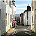
Walwers Lane
One of the medieval narrow lanes of Lewes that connected the High Street to the old town walls. Its name comes from an early 14th century MP for Lewes.
Image: © Simon Carey
Taken: 19 Aug 2012
0.03 miles
10
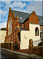
Lewes : former Methodist church
Built in 1867, closed in 1973. Architects: Pocock, Corfe and Parker
Image: © Jim Osley
Taken: 11 Feb 2024
0.04 miles