IMAGES TAKEN NEAR TO
Russell Row, LEWES, BN7 2ER
Introduction
This page details the photographs taken nearby to Russell Row, BN7 2ER by members of the Geograph project.
The Geograph project started in 2005 with the aim of publishing, organising and preserving representative images for every square kilometre of Great Britain, Ireland and the Isle of Man.

There are currently over 7.5m images from over14,400 individuals and you can help contribute to the project by visiting https://www.geograph.org.uk
Image Map (Loading...)


Getting Data...Please wait
Leaflet Map data © OpenStreetMap
Images are licensed for reuse under creativecommons.org/licenses/by-sa/2.0
Notes
- Clicking on the map will re-center to the selected point.
- The higher the marker number, the further away the image location is from the centre of the postcode.
Image Listing (24 Images Found)
Images are licensed for reuse under creativecommons.org/licenses/by-sa/2.0
Image
Details
Distance
1

Lewes Castle
If one stood here on 14th May 1264, one would see the Battle of Lewes raging in front between Henry III and the rebel barons led by Simon de Montfort. Henry lost and sought refuge in the priory. Next day he signed the Mise of Lewes, which gave Simon de Montfort a lot of power over the king.
Image: © Michael Garlick
Taken: 12 Mar 2015
0.10 miles
3
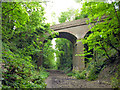
Bridge carrying road to Old Malling Farm
One of two bridges over the cutting once occupied by the Lewes to Uckfield railway line.
Image: © Robin Webster
Taken: 21 May 2014
0.11 miles
4
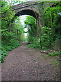
Railway Bridge
Crossing the track of the former Lewes-Uckfield line and carrying the road to Old Malling Farm. The line is now a public path from The Brooks to the southern end of the bridge across the Ouse.
Image: © Simon Carey
Taken: 29 Apr 2007
0.12 miles
5
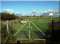
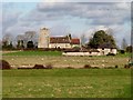
Metal gate at end of Monks Way, South Malling
Beyond is Hamsey Church and to the left where the scrub is lies the old railway line from Lewes to Uckfield closed over forty years ago. Since then there have been various projects to reopen the line, though in the present economical climate it is very unlikely to happen. Indeed, it could be argued that the project was always unlikely due to insufficient traffic between the two towns and as an unviable alternative rail route.
Image: © nick macneill
Taken: 9 Nov 2012
0.16 miles
9
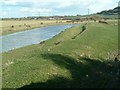
River Ouse at Malling
Looking east from the remnants of the old railway bridge that used to cross the river to Hamsey
Image: © David Saunders
Taken: 1 Mar 2006
0.21 miles
10
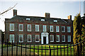
Malling House, Lewes
A C17th house refronted in the 1720s presenting an attractive face in red, grey and orange brick. It also has a fine Tuscan doorcase. The chimneystacks provided some vertical emphasis to counteract its predominant horizontality. Grade I listed.
The date of the photo is uncertain, but at the time this was used as offices by Sussex Police and in 2013 this still appears to be the case.
Image: © Stephen Richards
Taken: Unknown
0.22 miles