IMAGES TAKEN NEAR TO
Southcliffe, LEWES, BN7 2BZ
Introduction
This page details the photographs taken nearby to Southcliffe, BN7 2BZ by members of the Geograph project.
The Geograph project started in 2005 with the aim of publishing, organising and preserving representative images for every square kilometre of Great Britain, Ireland and the Isle of Man.

There are currently over 7.5m images from over14,400 individuals and you can help contribute to the project by visiting https://www.geograph.org.uk
Image Map
Images are licensed for reuse under creativecommons.org/licenses/by-sa/2.0
Notes
- Clicking on the map will re-center to the selected point.
- The higher the marker number, the further away the image location is from the centre of the postcode.
Image Listing (750 Images Found)
Images are licensed for reuse under creativecommons.org/licenses/by-sa/2.0
Image
Details
Distance
1
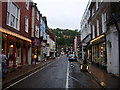
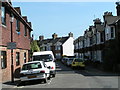
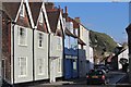
Cliffe High Street, Lewes
Looking east towards the junction with Malling Street and South Street. Until the 1960s this was the main road out of Lewes. Cliffe has long been a suburb of Lewes and grew out of its position as a crossing point over the river Ouse. It's still a shopping street but the eastern end thankfully is full of smaller shops rather than the big chain stores. Unfortunately, the area is still susceptible to flooding the last causing widespread damage a few years ago. This whole street was under water.
Image: © Simon Carey
Taken: 26 Oct 2005
0.03 miles
2
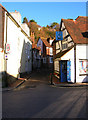
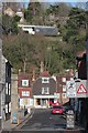
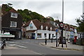
Chapel Hill
Located at the crossroads where Cliffe High Street meets Malling Street and South Street, all previously major roads until bypasses were built turning them into quiet backwaters. Chapel Hill leads up the hill eventually reaching the golf club which is perched on the cliffs above the town.
Image: © Simon Carey
Taken: 9 Dec 2006
0.03 miles
3
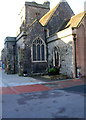
St Thomas a Becket Church, Cliffe High Street
Heavily restored 14th century church that serves the Cliffe suburb of Lewes.
Image: © Simon Carey
Taken: 9 Dec 2006
0.03 miles
4
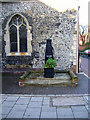
Water Pump, Cliffe High Street
Erected in 1830 and standing outside St Thomas a Becket church. Like most former pumps and troughs in Lewes it is now used as to hold plants.
Image: © Simon Carey
Taken: 9 Dec 2006
0.03 miles
7
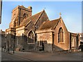
St Thomas a Becket church Lewes
Probably later C12 in origin, most of the church is C14 with a C15 tower. The windows were almost all replaced in the C19. The Royal Arms of 1598 are the oldest in Sussex. http://www.sussexparishchurches.org/content/view/262/34/
The church is located at the East end of Cliffe High Street
Image: © Paul Gillett
Taken: 27 Jan 2012
0.03 miles
10
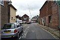
1, South Street
Grade II listed. http://www.britishlistedbuildings.co.uk/en-293423-1-south-street-lewes-east-sussex
Image: © N Chadwick
Taken: 12 Jul 2015
0.04 miles