IMAGES TAKEN NEAR TO
Castle Rise, LEWES, BN7 1UT
Introduction
This page details the photographs taken nearby to Castle Rise, BN7 1UT by members of the Geograph project.
The Geograph project started in 2005 with the aim of publishing, organising and preserving representative images for every square kilometre of Great Britain, Ireland and the Isle of Man.

There are currently over 7.5m images from over14,400 individuals and you can help contribute to the project by visiting https://www.geograph.org.uk
Image Map
Images are licensed for reuse under creativecommons.org/licenses/by-sa/2.0
Notes
- Clicking on the map will re-center to the selected point.
- The higher the marker number, the further away the image location is from the centre of the postcode.
Image Listing (835 Images Found)
Images are licensed for reuse under creativecommons.org/licenses/by-sa/2.0
Image
Details
Distance
1
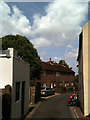
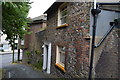
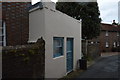
Castle Banks
Narrow lane connecting Castle Precinct to Mount Pleasant. The small white building on the left is The Trap House a former outbuilding that is now a residential extension of Garden Cottages. To the right is the Old Poorhouse whilst straight ahead are Mount Cottages erected in 1861.
Image: © Simon Carey
Taken: 24 May 2011
0.01 miles
2
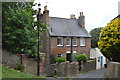
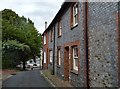
Garden Cottages
Grade II listed. http://www.britishlistedbuildings.co.uk/en-293495-garden-cottages-lewes-east-sussex
Image: © N Chadwick
Taken: 12 Jul 2015
0.01 miles
3
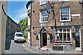
Public House - Lewes
The Lewes Arms, situated just outside the castle walls at Mount Place.
Image: © Colin Babb
Taken: 9 Jul 2010
0.01 miles
6
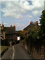
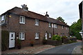
Castle Banks
Narrow lane connecting Castle Precincts to Mount Pleasant which at this point crosses the former castle ramparts. Garden Cottages are straight ahead.
Image: © Simon Carey
Taken: 24 May 2011
0.02 miles
9
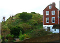
Brack Mound
An artificial motte believed to have been constructed by the Normans as part of the Lewes Castle complex. The stone buildings that did exist upon it fell into disrepair quite early on and had virtually gone by the 17th century. Excavations in 2001 discovered the keep's original well.
Image: © Simon Carey
Taken: 25 Nov 2006
0.03 miles
10
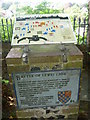
Viewing platform for the Battle of Lewes 1264
The information plaque here explains that on 14th May 1264 Simon de Montfort's army of 5,000 barons and Londoners defeated Royalist forces of twice that size under Henry III on the downs north-west of Lewes. The Mise of Lewes signed the next day led to the first English Parliament meeting at Westminster 20th January 1265. For the actual view see http://www.geograph.org.uk/photo/3120812 and see also http://www.geograph.org.uk/photo/3120904
Image: © Marathon
Taken: 6 Sep 2012
0.03 miles