IMAGES TAKEN NEAR TO
Garden Street, LEWES, BN7 1TJ

Introduction

This page details the photographs taken nearby to Garden Street, BN7 1TJ by members of the Geograph project.

The Geograph project started in 2005 with the aim of publishing, organising and preserving representative images for every square kilometre of Great Britain, Ireland and the Isle of Man.

There are currently over 7.5m images from over14,400 individuals and you can help contribute to the project by visiting https://www.geograph.org.uk

Image Map


Images are licensed for reuse under creativecommons.org/licenses/by-sa/2.0
Notes
  • Clicking on the map will re-center to the selected point.
  • The higher the marker number, the further away the image location is from the centre of the postcode.

Image Listing (848 Images Found)

Images are licensed for reuse under creativecommons.org/licenses/by-sa/2.0
  • ...
Image
Details
Distance
1
Tanners Brook
Is the name of the cul-de-sac on the left hand side of the picture. It was built on the site of the old cattle market in the 1990s. The green buildings to the right are also from the former cattle market and are now used as auction rooms. In the foreground are platforms 1 and 2 of Lewes station on the line that links Lewes with the main London-Brighton line between Burgess Hill and Wivelsfield.
Image: © Simon Carey Taken: 7 Oct 2006
0.03 miles
2
Lewes railway station (2)
These are platforms 1 and 2 on the line to and from London via Haywards Heath. A Southern Railway's eastbound train from London is just easing into the station from under the Southover Road bridge, with Unit Number 377443 leading.
Image: © Nigel Cox Taken: 20 Aug 2006
0.03 miles
3
Dorset Road
Small dead end road below Station Road (B2193). The houses on the southern side are older than those on the northern side.
Image: © Simon Carey Taken: 7 Oct 2006
0.03 miles
4
Priory Street
The B2193 viewed from the junction with Mountfield Road and Station Road. The street dates from around the 1830s though the actual highway is of a far greater antiquity being dated back to Roman times being part of a route that forded the Ouse near Southerham then ran along the modern day Mountfield Road, Priory Street, Southover High Street and Juggs Road before continuing westwards to Kingston then Brighton. For many centuries the road itself up to the junction with Southover High Street was known as Ham Lane before this section was renamed in the 1830s and that heading eastwards was renamed Mountfield Road in 1932.
Image: © Simon Carey Taken: 19 Aug 2012
0.04 miles
5
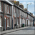
Houses on Priory Street
Image: © Ian Hawfinch Taken: 8 Apr 2023
0.04 miles
6
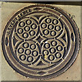
Coal Plate, Priory Street, Lewes
'J.Every Lewes' was a product of the Phoenix Ironworks, a local business that moved around in location in the town, but were probably in North Place when this was made.
Image: © Robin Webster Taken: 20 Jul 2016
0.04 miles
7
Mountfield Road Bridge, Lewes Station
Image: © N Chadwick Taken: 12 Jul 2015
0.05 miles
8
Building opposite Lewes Station
Image: © N Chadwick Taken: 14 Apr 2011
0.05 miles
9
Dismantled line, Lewes Station
Image: © N Chadwick Taken: 12 Jul 2015
0.05 miles
10
Waiting for a Train, Lewes Station
Viewing platforms 3 and 4 waiting for the 16.28 to take me back to Brighton.
Image: © Simon Carey Taken: 7 Oct 2006
0.06 miles
  • ...