IMAGES TAKEN NEAR TO
Tanners Brook, LEWES, BN7 1RU
Introduction
This page details the photographs taken nearby to Tanners Brook, BN7 1RU by members of the Geograph project.
The Geograph project started in 2005 with the aim of publishing, organising and preserving representative images for every square kilometre of Great Britain, Ireland and the Isle of Man.

There are currently over 7.5m images from over14,400 individuals and you can help contribute to the project by visiting https://www.geograph.org.uk
Image Map
Images are licensed for reuse under creativecommons.org/licenses/by-sa/2.0
Notes
- Clicking on the map will re-center to the selected point.
- The higher the marker number, the further away the image location is from the centre of the postcode.
Image Listing (995 Images Found)
Images are licensed for reuse under creativecommons.org/licenses/by-sa/2.0
Image
Details
Distance
3
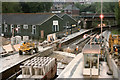
Lewes Station March 1986
Shown during the works to put the Winterbourne Stream into a culvert in order to prevent the stream flooding the station. The two green buildings are Auction Rooms but were proviously Army Huts from one of the First World War Camps in nearby Seaford.
Image: © Kevin Gordon
Taken: Unknown
0.02 miles
4
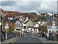
Weak bridge at Lewes Station
The road bridge outside Lewes station. The bridge is restricted to buses of not more than 11 tons, or other vehicles of no more than 6 tons.
To view the bridge from the opposite direction, see image Image
Image: © Malc McDonald
Taken: 30 Oct 2010
0.03 miles
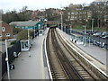
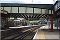
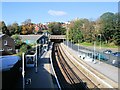
6
Lewes railway station
Two platforms of Lewes railway station. These platforms are on the line heading towards Haywards Heath and London. Trains on the line to and from Brighton use other platforms which are not visible in this view.
The railway is electrified using the third rail system.
Image: © Malc McDonald
Taken: 26 Oct 2019
0.03 miles
7
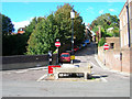
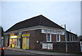
Water trough, Watergate Lane
Drinking fountain and cattle trough from the days when cattle and livestock were herded into the town from the surrounding farms. This also makes the point where the former Watergate stood in the old medieval town walls.
Image: © Simon Carey
Taken: 7 Oct 2006
0.03 miles
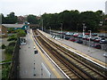
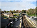
8
Lewes Station
viewed from Station Road looking along the platforms for trains to and from Hayward Heath and London
Image: © Paul Gillett
Taken: 27 Oct 2012
0.04 miles
9
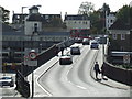
Weak bridge at Lewes station
The road bridge at Lewes Station has a weight limit of 11 tons for buses, and 6 tons for all other traffic. The double-deck bus on the opposite side of the bridge is heavier than 11 tons, and has therefore had to make a U-turn outside the station building.
Image: © Malc McDonald
Taken: 30 Oct 2010
0.04 miles