IMAGES TAKEN NEAR TO
Mount Street, LEWES, BN7 1HL
Introduction
This page details the photographs taken nearby to Mount Street, BN7 1HL by members of the Geograph project.
The Geograph project started in 2005 with the aim of publishing, organising and preserving representative images for every square kilometre of Great Britain, Ireland and the Isle of Man.

There are currently over 7.5m images from over14,400 individuals and you can help contribute to the project by visiting https://www.geograph.org.uk
Image Map
Images are licensed for reuse under creativecommons.org/licenses/by-sa/2.0
Notes
- Clicking on the map will re-center to the selected point.
- The higher the marker number, the further away the image location is from the centre of the postcode.
Image Listing (637 Images Found)
Images are licensed for reuse under creativecommons.org/licenses/by-sa/2.0
Image
Details
Distance
1
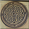
Coal Plate, Priory Street, Lewes
'J.Every Lewes' was a product of the Phoenix Ironworks, a local business that moved around in location in the town, but were probably in North Place when this was made.
Image: © Robin Webster
Taken: 20 Jul 2016
0.02 miles
2
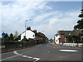
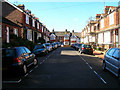
Priory Street
The B2193 viewed from the junction with Mountfield Road and Station Road. The street dates from around the 1830s though the actual highway is of a far greater antiquity being dated back to Roman times being part of a route that forded the Ouse near Southerham then ran along the modern day Mountfield Road, Priory Street, Southover High Street and Juggs Road before continuing westwards to Kingston then Brighton. For many centuries the road itself up to the junction with Southover High Street was known as Ham Lane before this section was renamed in the 1830s and that heading eastwards was renamed Mountfield Road in 1932.
Image: © Simon Carey
Taken: 19 Aug 2012
0.02 miles
4
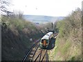
Cutting east of Lewes station
Taken from the Priory Street bridge, with an eastbound train approaching.
Image: © Stephen Craven
Taken: 5 Apr 2007
0.03 miles
5
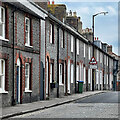
Dorset Road
Small dead end road below Station Road (B2193). The houses on the southern side are older than those on the northern side.
Image: © Simon Carey
Taken: 7 Oct 2006
0.03 miles
6
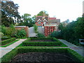
Knot Garden, Stream Gardens
Small garden within Stream Gardens in the grounds of Southover Grange.
Image: © Simon Carey
Taken: 7 Oct 2006
0.04 miles
7
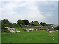
Church Ruins, Priory of St Pancras
The remains of the original church built in 1082 by William de Warrene and wife Gundrada on the site of an older Saxon church. This building was superseded by the larger priory church constructed over the following 200 years. The flint walls beyond are also part of the old priory and originally separated the priory buildings from the enclosed fields beyond. To the left is The Mount a small mound that may have origins as a defensive lookout.
Image: © Simon Carey
Taken: 19 Aug 2012
0.05 miles
8

Ruins of the Great Church at Lewes Priory
Image: © PAUL FARMER
Taken: 23 Nov 2012
0.05 miles
9
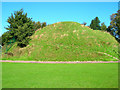
The Mount (Calvary)
A former defensive mound given to St Pancras' Priory in 1077 when the land on which this stands was given over to the Cluniac order and William de Warenne decided to build himself a castle further up the hill. Stories are also told that the mound was used as a Calvary hill when monks out of penance had to walk up to the top with a cross over their shoulder, though a more realistic story appears to be that it was the home to the priory's windmill. Crosses are still taken to the top of the mound on Good Friday along the spiral pathway which can be made out though the mound has lost part of the left hand side when the bowling club cut a chunk out in order to build a bowling green during the Victorian era.
Image: © Simon Carey
Taken: 7 Oct 2006
0.05 miles
10
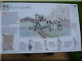
Information board about the Herb Garden, Lewes Priory
The Priory of St Pancras was founded between 1078 and 1082 by William de Warenne, 1st Earl of Surrey, and Gundrada his wife. It was one of the largest and most powerful monasteries in England and was the first Priory in England linked to the influential Abbey of Cluny in Burgundy. Most of it was deliberately destroyed during the Reformation in 1538. The Priory became a quarry for building materials, many of which can still be seen in buildings throughout Lewes. This is the information board about the Herb Garden seen at http://www.geograph.org.uk/photo/3120958
Image: © Marathon
Taken: 6 Sep 2012
0.05 miles