IMAGES TAKEN NEAR TO
Marchants Close, HASSOCKS, BN6 9UZ
Introduction
This page details the photographs taken nearby to Marchants Close, BN6 9UZ by members of the Geograph project.
The Geograph project started in 2005 with the aim of publishing, organising and preserving representative images for every square kilometre of Great Britain, Ireland and the Isle of Man.

There are currently over 7.5m images from over14,400 individuals and you can help contribute to the project by visiting https://www.geograph.org.uk
Image Map
Images are licensed for reuse under creativecommons.org/licenses/by-sa/2.0
Notes
- Clicking on the map will re-center to the selected point.
- The higher the marker number, the further away the image location is from the centre of the postcode.
Image Listing (75 Images Found)
Images are licensed for reuse under creativecommons.org/licenses/by-sa/2.0
Image
Details
Distance
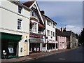
1
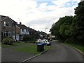
Marchants Close, Hurstpierpoint
Small cup de sac off Marchants Road that is part of an estate built in the late 60s/early 70s. Beyond the trees to the right are ponds belonging to Little Park Farm.
Image: © Simon Carey
Taken: 6 Jul 2014
0.06 miles
3

Hurstpierpoint Health Centre, Trinity Road, Hurstpierpoint
Built in 1978 along with neighbouring Image
Image: © Simon Carey
Taken: 31 May 2014
0.12 miles
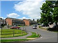
4
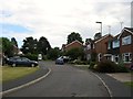
Park Close, Hurstpierpoint
A small cup de sac off Marchants Road. Beyond the fence in the distance is Trinity Road.
Image: © Simon Carey
Taken: 6 Jul 2014
0.12 miles
5
The Glebe, Hurstpierpoint
Small cul de sac off Trinity Road which is a retirement estate built on the site of a former house of the same name.
Image: © Simon Carey
Taken: 7 Jun 2014
0.13 miles
6
Buildings opposite South Avenue, Hurstpierpoint
Image: © Ian Hawfinch
Taken: 25 Aug 2005
0.14 miles
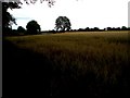
7
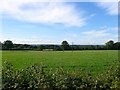
Edgerley Meadow
The name of the field according to Hurspierpoint's 1842 tithe map that lies to the north of Image and west of Image The latter contains a house called Big Edgerley whilst beyond the hedgerow in the distance is another called Little Edgerley.
Image: © Simon Carey
Taken: 7 Jun 2014
0.14 miles
8
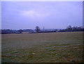
Electricity Poles near Big Edgerley
Taken from the footpath that links St George's Lane with Trinity Road. A small speck of light appears in an otherwise dull day, the cloud cover making it impossible for the sun to get at the previous night's frost which still lies on the ground 30 minutes before sunset.
Image: © Simon Carey
Taken: 4 Jan 2009
0.14 miles
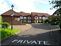
9
Ribbetts House, Trinity Road, Hurstpierpoint
Sheltered housing built in 1978 that is squeezed between Trinity Road and High Street.
Image: © Simon Carey
Taken: 31 May 2014
0.14 miles
10
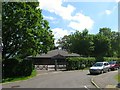
Scout Hall, Brown Twins Road, Hurstpierpoint
Modern building equipped with hall, meeting room and kitchen that replaced the older one now used as Hurstpierpoint Charity Shop.
Image: © Simon Carey
Taken: 31 May 2014
0.15 miles