IMAGES TAKEN NEAR TO
High Street, HASSOCKS, BN6 9RG
Introduction
This page details the photographs taken nearby to High Street, BN6 9RG by members of the Geograph project.
The Geograph project started in 2005 with the aim of publishing, organising and preserving representative images for every square kilometre of Great Britain, Ireland and the Isle of Man.

There are currently over 7.5m images from over14,400 individuals and you can help contribute to the project by visiting https://www.geograph.org.uk
Image Map
Images are licensed for reuse under creativecommons.org/licenses/by-sa/2.0
Notes
- Clicking on the map will re-center to the selected point.
- The higher the marker number, the further away the image location is from the centre of the postcode.
Image Listing (258 Images Found)
Images are licensed for reuse under creativecommons.org/licenses/by-sa/2.0
Image
Details
Distance
1
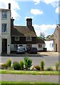
48 High Street, Hurstpierpoint
The house dates from the 17th century and seems to be dwarfed by the latter Victorian and edwardian structures next to it.
Image: © Simon Carey
Taken: 31 May 2014
0.00 miles
2
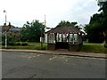
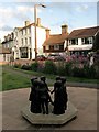
Bus shelter with bunting
The bunting for the Queen's official 90th birthday I assume.
Image: © David Lally
Taken: 11 Jun 2016
0.01 miles
3
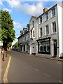
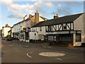
50-58, High Street, Hurstpierpoint
Looking eastwards down the High Street where it narrows as it passes these shops.
Image: © Simon Carey
Taken: 13 Jul 2014
0.02 miles
6
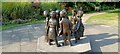
Children of the Fair, Hurstpierpoint
The sculpture by local resident Sylvia Thornhill was unveiled in 2013 to celebrate 700 years of St Lawrence's Fair whose charter was originally granted by Edward II in 1313. There are seven children in a circle each dressed in the fashion of each century from the 14th to the present day. The sculpture is located on a small green at the western end of the High Street.
Image: © Simon Carey
Taken: 13 Jul 2014
0.02 miles
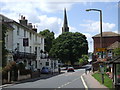
7
28-44, High Street, Hurstpierpoint
Viewed from the crossroads with Brighton and Cuckfield Roads. This is the western end of the shopping area of the village.
Image: © Simon Carey
Taken: 13 Jul 2014
0.02 miles
8
Hurst Community Charity Shop, Hurstpierpoint
Set up in the late 1990s to raise money for Holy Trinity church and other local causes within the parish. Parking tickets for the adjacent Trinity Road car park can also be purchased here.
Image: © Simon Carey
Taken: 13 Jul 2014
0.02 miles
9
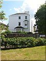
Chantry House, High Street, Hurstpierpoint
A former 19th century mansion house that was once the village rectory has now been converted into upmarket flats.
Image: © Simon Carey
Taken: 7 Aug 2014
0.03 miles
10
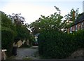
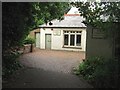
Little Park Lane, Hurstpierpoint
Small private drive containing just two buildings, one of which, on the right, is Rectory Cottage which dates from the early 19th century. The lane is located off Trinity Road.
Image: © Simon Carey
Taken: 6 Jul 2014
0.04 miles