IMAGES TAKEN NEAR TO
High Street, HASSOCKS, BN6 9PY
Introduction
This page details the photographs taken nearby to High Street, BN6 9PY by members of the Geograph project.
The Geograph project started in 2005 with the aim of publishing, organising and preserving representative images for every square kilometre of Great Britain, Ireland and the Isle of Man.

There are currently over 7.5m images from over14,400 individuals and you can help contribute to the project by visiting https://www.geograph.org.uk
Image Map
Images are licensed for reuse under creativecommons.org/licenses/by-sa/2.0
Notes
- Clicking on the map will re-center to the selected point.
- The higher the marker number, the further away the image location is from the centre of the postcode.
Image Listing (244 Images Found)
Images are licensed for reuse under creativecommons.org/licenses/by-sa/2.0
Image
Details
Distance
1
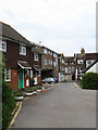
Pitt Lane
Lane running south from the High Street. The white building on the left is the Old Forge.
Image: © Simon Carey
Taken: 10 May 2009
0.01 miles
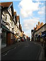
2

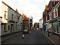
High Street, Hurstpierpoint
The width of the High Street changes a number of times between the eastern end and the junction with Brighton and Cuckfield Roads, in the distance it narrows to a single lane. Unlike many villages of its size Hurstpierpoint's is well stocked with small shops and cafes.
Image: © Simon Carey
Taken: 22 Jun 2014
0.01 miles
3
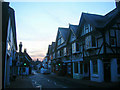
High Street
Taken at dawn where Hurstpierpoint's main street briefly narrows. The street itself seems very traditional with largely small independent shops.
Image: © Simon Carey
Taken: 4 Jan 2009
0.02 miles
4
Cards Place, High Street, Hurstpierpoint
The name of the parade of shops, numbered 90-100 High Street, on the left built in 1900. In the distance is Image The village has a healthy high street with a number of small independent businesses and still possess their own butcher, fishmonger and grocer. The only major supermarket chain is a small Co-op.
Image: © Simon Carey
Taken: 7 Aug 2014
0.02 miles
5
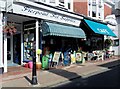
Pet shop and cafe, Hurstpierpoint
Hurstpierpoint is a charming small town that still has shops with canopies as seen here.
Image: © nick macneill
Taken: 31 Aug 2012
0.03 miles
6

Pitt Lane, Hurstpierpoint
On the right beyond the public conveniences is Image whilst beyond that is The Old Forge. Pitt Lane has gentrified over the years having gained an extra 't'. At the far end is its junction with High Street.
Image: © Simon Carey
Taken: 22 Jun 2014
0.03 miles
7
New Inn, High Street, Hurstpierpoint
The main pub in the town was new when it replaced an older inn around 1450, though the Georgian facade hides a much earlier Tudor timbered building and was also the village corn exchange for a while. Beyond the inn is Mansion House, another building that dates from the 15th century which was extended and refronted in the 18th century. Between 1849-53 it was home to St John's College before moving to its current home to the north of the village. In the distance on the right are Image
Image: © Simon Carey
Taken: 7 Aug 2014
0.03 miles
10
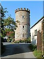
The Tower, Hurstpierpoint
A 19th century folly tower built in what was the grounds of Mansion House
Image: © Simon Carey
Taken: 17 Jul 2014
0.04 miles