IMAGES TAKEN NEAR TO
Pomper Lane, HASSOCKS, BN6 9LJ
Introduction
This page details the photographs taken nearby to Pomper Lane, BN6 9LJ by members of the Geograph project.
The Geograph project started in 2005 with the aim of publishing, organising and preserving representative images for every square kilometre of Great Britain, Ireland and the Isle of Man.

There are currently over 7.5m images from over14,400 individuals and you can help contribute to the project by visiting https://www.geograph.org.uk
Image Map
Images are licensed for reuse under creativecommons.org/licenses/by-sa/2.0
Notes
- Clicking on the map will re-center to the selected point.
- The higher the marker number, the further away the image location is from the centre of the postcode.
Image Listing (30 Images Found)
Images are licensed for reuse under creativecommons.org/licenses/by-sa/2.0
Image
Details
Distance
1
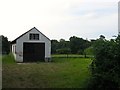
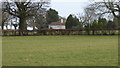
Pomper Field
The name of the field according to Hurstpierpoint's 1842 tithe map that lies south of Pomper Lane and east of Image beyond which is Image, that probably suggests that this was once part of that field and was split by the construction of Cuckfield turnpike in the early 19th century. Much of the field east of the road has been subdivided and built upon.
Image: © Simon Carey
Taken: 25 Jul 2014
0.04 miles
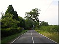
2
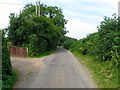
Pomper Lane
Narrow single track lane that runs westwards from Danworth Lane to Northend Lane crossing Cuckfield Road along the way.
Image: © Simon Carey
Taken: 25 Jul 2014
0.06 miles
3
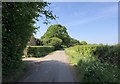
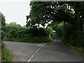
Pomper Lane
Heading westwards on Pomper Lane near to Penharbour Farm Cottage.
Image: © Chris Thomas-Atkin
Taken: 7 May 2020
0.07 miles
4
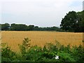
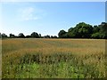
Copse Field
The name of the field according to Hurstpierpoint's 1842 tithe map that lies to the north of Pomper lane, east of Cuckfield Road and south and west of Northend Copse, part of which can be seen on the right.
Image: © Simon Carey
Taken: 25 Jul 2014
0.07 miles
5
House on Cuckfield Road seen from footpath to the west
Image: © Shazz
Taken: 24 Dec 2016
0.09 miles
6
Site of Three Acre Copse
The name of the field according to Hurstpierpoint's 1842 tithe map that was once a wood, part of neighbouring North End Copse, that has since been cleared and turned into a field. At the far end of the field are the houses on Pomper Lane. The field is bounded to the south by Image
Image: © Simon Carey
Taken: 22 Jul 2014
0.11 miles
7
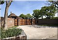
Entrance to Potters
The impressive entrance off Pomper Lane to the property known as Potters.
Image: © Chris Thomas-Atkin
Taken: 7 May 2020
0.12 miles
8
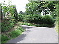
Minor roads junction, south of Goddard's Green
Image: © nick macneill
Taken: 12 Aug 2011
0.12 miles
9
Cuckfield Road
Turnpike built in the early 19th century connecting to other London-Brighton routes, namely those followed by the modern A273 and A23. This view looks south from the crossroads with Pomper Lane. Beyond the hedge to the left is Hill House whilst beyond that on right is Image
Image: © Simon Carey
Taken: 25 Jul 2014
0.14 miles
10
High Hatch Lane
The road name changes from Danworth Lane at the junction with Pomper Lane. The lane continues northwards to Goddards Green.
Image: © Simon Carey
Taken: 25 Jul 2014
0.14 miles