IMAGES TAKEN NEAR TO
Twineham Lane, HASSOCKS, BN6 9JE
Introduction
This page details the photographs taken nearby to Twineham Lane, BN6 9JE by members of the Geograph project.
The Geograph project started in 2005 with the aim of publishing, organising and preserving representative images for every square kilometre of Great Britain, Ireland and the Isle of Man.

There are currently over 7.5m images from over14,400 individuals and you can help contribute to the project by visiting https://www.geograph.org.uk
Image Map
Images are licensed for reuse under creativecommons.org/licenses/by-sa/2.0
Notes
- Clicking on the map will re-center to the selected point.
- The higher the marker number, the further away the image location is from the centre of the postcode.
Image Listing (44 Images Found)
Images are licensed for reuse under creativecommons.org/licenses/by-sa/2.0
Image
Details
Distance
1

High Cross Cottages
See also http://www.geograph.org.uk/photo/3961020.
Image: © Shazz
Taken: 8 Jan 2017
0.01 miles
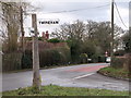
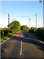
2
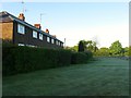
High Cross Cottages, Twineham Lane, High Cross
Built in the 1930s for agricultural workers at nearby Reeds Farm. The terrace fills the small gap between Henfield Road and Reeds Lane.
Image: © Simon Carey
Taken: 3 May 2014
0.01 miles
3
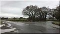
Reed?s Lane
The junction of Reed’s Lane and Twineham Lane.
Image: © Chris Thomas-Atkin
Taken: 31 Dec 2017
0.02 miles
4
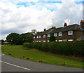
High Cross
Small hamlet on the B2116 Albourne-Henfield road. These cottages are on Twineham Lane, the junction to Reeds Lane at the far end of the row.
Image: © Simon Carey
Taken: 26 Aug 2006
0.02 miles
5
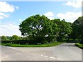
Site of High Cross Gate
Located at the junction of Twineham Lane and Reeds Lane the area in front of the road sign was once the site of a tollhouse called High Cross Gate that charged road users for travel along the latter to the main London-Brighton turnpike which later became the A23. The tollhouse was marked on the 1874 OS map but the road was disturnpiked in 1876 and disappeared soon after. The OS map also has a small circular pond in front of the old building roughly where the dark triangular patch in the road is. To the immediate south out of shot is Image whilst the field beyond is Image
Image: © Simon Carey
Taken: 3 May 2014
0.03 miles
6
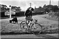
Checking The Route
A Cyclist Touring Club member taking part in a map reading event.
Image: © Peter Jeffery
Taken: Unknown
0.03 miles
7
Road sign on Junction between Twineham Road and B2116
Image: © nick macneill
Taken: 11 Jan 2011
0.03 miles
8
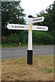
Direction Sign - Signpost by the B2116 at High Cross
Black iron cap finial - 3 arms; East Sussex wood by the B2116, in parish of Albourne (Mid Sussex District), junction of Twineham Lane with B2116 Henfield Road, on grass triangle.
Surveyed
Milestone Society National ID: SX_TQ2517
Image: © Milestone Society
Taken: Unknown
0.03 miles
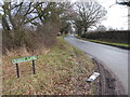
10
Henfield Road, High Cross
The b2116 heading westwards through the small hamlet and past a couple of junctions: in the foreground is Twineham Lane which heads north and little further along Trusslers Hill Lane that heads south.
Image: © Simon Carey
Taken: 3 May 2014
0.03 miles