IMAGES TAKEN NEAR TO
Nightingale Way, BN6 9HP
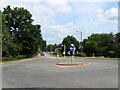
Introduction
This page details the photographs taken nearby to Nightingale Way, BN6 9HP by members of the Geograph project.
The Geograph project started in 2005 with the aim of publishing, organising and preserving representative images for every square kilometre of Great Britain, Ireland and the Isle of Man.

There are currently over 7.5m images from over14,400 individuals and you can help contribute to the project by visiting https://www.geograph.org.uk
Image Map
Images are licensed for reuse under creativecommons.org/licenses/by-sa/2.0
Notes
- Clicking on the map will re-center to the selected point.
- The higher the marker number, the further away the image location is from the centre of the postcode.
Image Listing (55 Images Found)
Images are licensed for reuse under creativecommons.org/licenses/by-sa/2.0
Image
Details
Distance
1
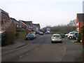
Dunlop Close
Modern housing development to the west of London Road, the former A23.
Image: © Simon Carey
Taken: 4 Jan 2009
0.10 miles
2
Sayers Common, West Sussex
A view facing south east down the old A23 into Sayers Common village.
Image: © Chris Plunkett
Taken: 27 Nov 2005
0.12 miles
3
Brick Kiln Field
The name of the field according to Hurstpierpoint's 1842 tithe map and like many Sussex brick works originally located on a common prior to its enclosure. The brick and tile works would remain here up to the Second World War after which the field and former clay pits have been left to nature. Furzefield is the wood on the left.
Image: © Simon Carey
Taken: 17 Aug 2014
0.12 miles
4
Aymers, London Road
Viewed from the junction with Berrylands Farm, a listed Wealden house on the former A23.
Image: © Simon Carey
Taken: 4 Jan 2009
0.12 miles
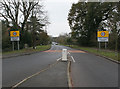
5
London Road, Sayers Common
Looking north from the junction with Reeds Lane. Now the B2118, it was until the early 1990s the main A23 trunk road.
Image: © Simon Carey
Taken: 31 Jul 2014
0.13 miles
6
Three Acres
The name of the field according to Hurstpierpoint's 1842 tithe map that lies to the south of the drive to LVS Hassocks.
Image: © Simon Carey
Taken: 31 Jul 2014
0.13 miles
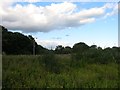
7
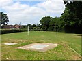
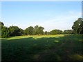
Playing Field, Sayers Common
Lying immediately to the north of Reeds Lane and indeed once part of Sayers Common, an open area of ground that existed here well before the houses arrived.
Image: © Simon Carey
Taken: 31 Jul 2014
0.14 miles
8
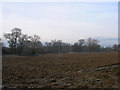
Frozen Field near London Road
Taken from the bridleway that forms the driveway to the Priory of Our Lady.
Image: © Simon Carey
Taken: 4 Jan 2009
0.14 miles
9
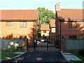
Dukes Place, Sayers Common
A gated estate of 6 houses built in 2013 off London Road.
Image: © Simon Carey
Taken: 17 Aug 2014
0.14 miles
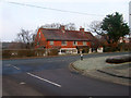
10
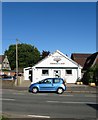
Village Hall Community Shop, London Road, Sayers Common
The village hall dates from the interwar period and is located next door to Image In 2011 it agreed that the expanding village of Sayers Common needed a local shop to replace the previous one that had closed in 2001. The result was a community shop attached to the village hall that opened in April 2014.
Image: © Simon Carey
Taken: 17 Aug 2014
0.15 miles