IMAGES TAKEN NEAR TO
Sandy Lane, HASSOCKS, BN6 9FX
Introduction
This page details the photographs taken nearby to Sandy Lane, BN6 9FX by members of the Geograph project.
The Geograph project started in 2005 with the aim of publishing, organising and preserving representative images for every square kilometre of Great Britain, Ireland and the Isle of Man.

There are currently over 7.5m images from over14,400 individuals and you can help contribute to the project by visiting https://www.geograph.org.uk
Image Map
Images are licensed for reuse under creativecommons.org/licenses/by-sa/2.0
Notes
- Clicking on the map will re-center to the selected point.
- The higher the marker number, the further away the image location is from the centre of the postcode.
Image Listing (21 Images Found)
Images are licensed for reuse under creativecommons.org/licenses/by-sa/2.0
Image
Details
Distance
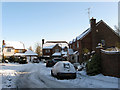
1
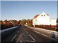
Brighton Road
Looking up the A273 as it travels towards Stonepound Crossroads. The road closely follows the course of an old Roman road and was a major London-Brighton coaching route from the 18th century.
Image: © Simon Carey
Taken: 20 Dec 2009
0.07 miles
2
A273 Brighton Road, Hassocks
A view towards Brighton from a bus at the stop here.
Image: © Robin Webster
Taken: 13 Apr 2019
0.08 miles
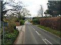
3
Sandy Lane
Road junction in Hassocks.
Image: © Wayland Smith
Taken: 17 Sep 2022
0.08 miles
4
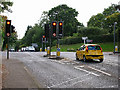
Stonepound Crossroads, Hassocks
Looking south. The A273 was built as a turnpike towards the end of the 18th century to cater for the increasing popularity of Brighton. Stonepound Gate was where the tolls were collected for those heading south. Hassocks, like Haywards Heath and Burgess Hill owes its existence to the railways. When the station was built it was to service the nearby village of Keymer, Hassocks as an entity did not exist.
Image: © Simon Carey
Taken: 24 Sep 2005
0.10 miles
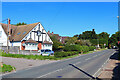
5
Pound Gate
Small cul-de-sac off Brighton Road, the A273.
Image: © Simon Carey
Taken: 20 Dec 2009
0.11 miles
6
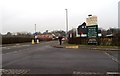
Entrance to South Downs Nursery, Hassocks
Image: © nick macneill
Taken: 17 Feb 2012
0.12 miles
7
Typical direction sign board, Hassocks
Image: © nick macneill
Taken: 12 Aug 2011
0.13 miles
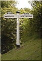
8
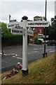
Signpost at Stonepound Crossroads
These days very much secondary to the more modern signage, this delightful wooden fingerpost has been retained at the busy crossroads where the A273 meets the B2116. Signposts of this design can be found across Sussex: see also Image
Image: © Stephen McKay
Taken: 7 Sep 2021
0.13 miles
9

South Downs Nurseries
Formerly Clayton Nurseries which had been operating on the site since 1922. The garden centre includes a cafe and a heritage centre displaying implements from bygone agricultural practices as well as growing vintage varieties of Sussex fruits.
Image: © Simon Carey
Taken: 20 Dec 2009
0.13 miles
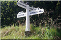
10
Old Direction Sign - Signpost by the A273, Stonepound Crossroads
Black iron cap finial - 4 arms; East Sussex wood with number by the A273, in parish of Hassocks (District), crossroads where the B2116, Keymer Road and Hurst Road, intersects with the A273, on grass bank above drinking trough.
Surveyed
Milestone Society National ID: SX_TQ2915
Image: © Milestone Society
Taken: Unknown
0.14 miles