IMAGES TAKEN NEAR TO
Langton Lane, HASSOCKS, BN6 9EZ
Introduction
This page details the photographs taken nearby to Langton Lane, BN6 9EZ by members of the Geograph project.
The Geograph project started in 2005 with the aim of publishing, organising and preserving representative images for every square kilometre of Great Britain, Ireland and the Isle of Man.

There are currently over 7.5m images from over14,400 individuals and you can help contribute to the project by visiting https://www.geograph.org.uk
Image Map (Loading...)


Getting Data...Please wait
Leaflet Map data © OpenStreetMap
Images are licensed for reuse under creativecommons.org/licenses/by-sa/2.0
Notes
- Clicking on the map will re-center to the selected point.
- The higher the marker number, the further away the image location is from the centre of the postcode.
Image Listing (31 Images Found)
Images are licensed for reuse under creativecommons.org/licenses/by-sa/2.0
Image
Details
Distance
1
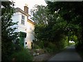
Hurst View, Langton Lane
Built between the wars and originally known as Knowl's Tooth Cottage. the house appears to have been extended in the 60s or 70s. It lies to the north of Image
Image: © Simon Carey
Taken: 31 Jul 2014
0.01 miles
2
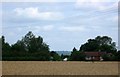
Coombe Cottage, Langton Lane
Viewed from the south across an unnamed field. The building seems to date from the mid 19th century.
Image: © Simon Carey
Taken: 31 Jul 2014
0.01 miles
4
The Long House, Langton Lane
Modern house built in the 1970s to the immediate north of Image
Image: © Simon Carey
Taken: 6 Jul 2014
0.02 miles
5
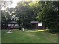
Knowles Tooth, Langton Lane
Part of the house dates back to the 17th century with an early 19th century extension. Since 1974 it has been owned by the Church of England charity, Family Support Work, who have run it as a children's holiday centre for disadvantaged families. In October 2013 it announced it would no longer accept bookings and would close the centre as it could no longer afford to keep it operable.
Image: © Simon Carey
Taken: 6 Jul 2014
0.07 miles
6
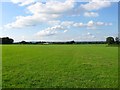
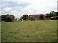
Knowl's Tooth Field
The name of the field according to Hurstpierpoint's 1842 tithe map which shares its name with nearby Image The field lies next to Langton Lane to the west, Image to the east and Eight and a Half Acres to the north.
Image: © Simon Carey
Taken: 13 Jul 2014
0.09 miles
7
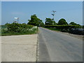
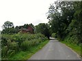
Langton Lane north to Mill Lane
Behind the bridleway marker is another signpost which reads ASC The Weald. On a google search it appears there is a connection with a naturist holiday company.
Image: © Dave Spicer
Taken: 30 Apr 2011
0.12 miles
8
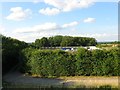
Sayers Common Wood
This part of the wood has been separated by the rest by the construction of the new course of the A23 in the early 1990s. Beyond the hedge is a depot whilst within the wood itself is a naturist camping site.
Image: © Simon Carey
Taken: 13 Jul 2014
0.17 miles
10
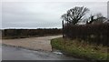
Langton Lane
A path leading off Langton Lane and heading towards Coombe Farm.
Image: © Chris Thomas-Atkin
Taken: 31 Dec 2017
0.17 miles