IMAGES TAKEN NEAR TO
London Road, HASSOCKS, BN6 9BJ
Introduction
This page details the photographs taken nearby to London Road, BN6 9BJ by members of the Geograph project.
The Geograph project started in 2005 with the aim of publishing, organising and preserving representative images for every square kilometre of Great Britain, Ireland and the Isle of Man.

There are currently over 7.5m images from over14,400 individuals and you can help contribute to the project by visiting https://www.geograph.org.uk
Image Map
Images are licensed for reuse under creativecommons.org/licenses/by-sa/2.0
Notes
- Clicking on the map will re-center to the selected point.
- The higher the marker number, the further away the image location is from the centre of the postcode.
Image Listing (40 Images Found)
Images are licensed for reuse under creativecommons.org/licenses/by-sa/2.0
Image
Details
Distance
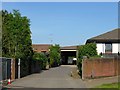
1
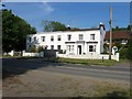
Arden Grange Kennels, London Road, Albourne
Arden Grange was built as a house between the wars and was turned into kennels sometime in the 1970s. The present owners took over in 1981 and expanded into the production of specialist pet food in 1996, which bears the name of the house.
Image: © Simon Carey
Taken: 16 May 2014
0.09 miles
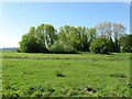
2
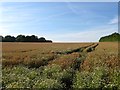
South Mead
The name of the field according to Hurstpierpoint's 1842 tithe map that has been extended to include Image to the north. The field lies between the old and new courses of the A23.
Image: © Simon Carey
Taken: 17 Jul 2014
0.09 miles
3
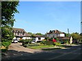
Elm Studio/Elm House/Mole Manor, London Road, Albourne
Actually located on the Hurstpierpoint side of the road but part of the village of Albourne. Elm House located in the centre was originally known as Elm Villa and was built in the early 19th century when on what had recently become the main London-Brighton road. To its left is Elm Studio, a modern edition built in the same style, whilst on the right is Mole Manor which dates from the 17th century. Another building is attached to the south of this, out of shot, called Tipnoaks which dates from the same period as Elm House and is built in the same style.
Image: © Simon Carey
Taken: 16 May 2014
0.10 miles
4
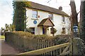
Woodbine Cottage
The blue plaque on the wall reads;- "Father of the British Cycle Industry James Starley 1830-1881 lived at the original Woodbine Cottage until 1846".
Image: © Peter Jeffery
Taken: 1 Feb 2009
0.11 miles
5
Hop Garden Field
The name of the field according to Albourne's 1839 tithe map which for many years was home to Hazelden's Nursery which has now gone leaving just the concrete standing as a reminder.
Image: © Simon Carey
Taken: 3 May 2014
0.11 miles
6
Fed Ex Depot, Arden Grange, London Road, Albourne
Part of the complex that also includes Image to the north.
Image: © Simon Carey
Taken: 16 May 2014
0.11 miles
7
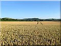
Latters
The name of the field according to Hurstpierpoint's 1842 tithe map that has been extended to include Image to the south. In the distance are, from left to right, Wolstonbury Hill, Newtimber Hill and Fulking Hill.
Image: © Simon Carey
Taken: 17 Jul 2014
0.12 miles
8
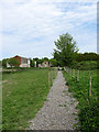
Footpath to London Road
Heading east from a junction of footpaths south of Yew Tree House towards the B2118. The disused building on the left was possibly once part of Hazeldens Nurseries.
Image: © Simon Carey
Taken: 10 May 2009
0.14 miles

10
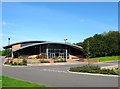
Brethren Gospel Hall, Albourne
Planning permission was given in 2009 and opened a few years later. Previously the land had been part of Hazelden's Nursery, see Image According to Albourne's 1839 tithe map the land the hall and car park occupy was once a field called Farm Close.
Image: © Simon Carey
Taken: 3 May 2014
0.15 miles