IMAGES TAKEN NEAR TO
New Way Lane, HASSOCKS, BN6 9BE
Introduction
This page details the photographs taken nearby to New Way Lane, BN6 9BE by members of the Geograph project.
The Geograph project started in 2005 with the aim of publishing, organising and preserving representative images for every square kilometre of Great Britain, Ireland and the Isle of Man.

There are currently over 7.5m images from over14,400 individuals and you can help contribute to the project by visiting https://www.geograph.org.uk
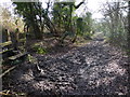
Image Map
Images are licensed for reuse under creativecommons.org/licenses/by-sa/2.0
Notes
- Clicking on the map will re-center to the selected point.
- The higher the marker number, the further away the image location is from the centre of the postcode.
Image Listing (41 Images Found)
Images are licensed for reuse under creativecommons.org/licenses/by-sa/2.0
Image
Details
Distance
1
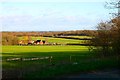
Coldharbour Farm
From Underhill Lane. Coldharbour Farm is adjacent to the Roman Road from London to Brighton.
Image: © Peter Jeffery
Taken: 1 Jan 2007
0.00 miles
2
Coldharbour Farm
Coldharbour derives from the Saxon 'cald hereboerg' meaning a temporary army settlement or which developed into the medieval roadside shelter for travellers caught out in the elements. Many of these were located on main thoroughfares and are usually an indication of a nearby Roman road. The route from London to the coast ran near here though the actual route is disputed, some say the road ran through the farm ahead others say it closely followed the course of the current A273 before it ascended Clayton then made its way to the coast possibly at Portslade. The current footpath which follows the drive links New Way Lane with the B2116.
Image: © Simon Carey
Taken: 10 May 2009
0.01 miles
3
Coldharbour Farm
Such a name is a good clue to the possibility of a nearby Roman Road. This is correct here, as the course of the London - south coast road passes nearby to the right, although opinions differ on just how close nearby the local alignment was - both of two postulated alignments may have coexisted.
Image: © Robin Webster
Taken: 23 Jan 2011
0.01 miles
4
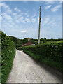
Farm access road near Clayton
An access road leading to Coldharbour Farm in the West Sussex countryside. The road is a public right of way for pedestrians, another footpath leads off to the right as indicated by the wooden signpost.
Image: © Malc McDonald
Taken: 13 Apr 2019
0.01 miles
6
Footpath to Hautboyes
Following the line of the fence next to southern edge of Patson's Copse.
Image: © Simon Carey
Taken: 10 May 2009
0.07 miles
7
Patson's Copse
Small wood next to Coldharbour Farm.
Image: © Simon Carey
Taken: 20 Dec 2009
0.07 miles
8
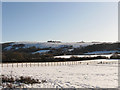
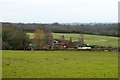
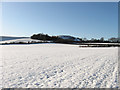
Four Acre Mead
The name of the field according to the 1838 tithe map that has now been subdivided into two paddocks. The village of Clayton can be seen in the middle distance whilst beyond and above on Clayton Hill are the Jack & Jill windmills.
Image: © Simon Carey
Taken: 20 Dec 2009
0.08 miles
9
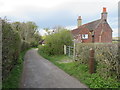
Footpath stile and junction on the way to Coldharbour Farm
Image: © Shazz
Taken: 13 Feb 2017
0.08 miles
10
Eight Acres
The name of this section of the field according to the 1838 tithe map which has been enlarged to include Nine Acres to the east. Round Hill can be seen at the end of the field.
Image: © Simon Carey
Taken: 20 Dec 2009
0.08 miles