IMAGES TAKEN NEAR TO
New Way Lane, HASSOCKS, BN6 9BA
Introduction
This page details the photographs taken nearby to New Way Lane, BN6 9BA by members of the Geograph project.
The Geograph project started in 2005 with the aim of publishing, organising and preserving representative images for every square kilometre of Great Britain, Ireland and the Isle of Man.

There are currently over 7.5m images from over14,400 individuals and you can help contribute to the project by visiting https://www.geograph.org.uk
Image Map
Images are licensed for reuse under creativecommons.org/licenses/by-sa/2.0
Notes
- Clicking on the map will re-center to the selected point.
- The higher the marker number, the further away the image location is from the centre of the postcode.
Image Listing (32 Images Found)
Images are licensed for reuse under creativecommons.org/licenses/by-sa/2.0
Image
Details
Distance
1

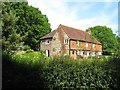
Sandfield Cottages, New Way Lane
Not marked on the 1842 tithe map but do appear on the 1875 OS map which gives some idea to the date of their construction. The Sand Field in question is Image which lies immediately behind to the north west, whilst across the lane beyond the trees to the east is Image which until recently was the site of Hassocks Sandpit. Cottages and fields lie on a small ridge of greensand. New Way Lane dates from around the 16th century and was constructed by the owners of Danny House to replace an older and narrow lane that ran south eastwards to Image from the village of Hurstpierpoint.
Image: © Simon Carey
Taken: 22 Jun 2014
0.01 miles
2

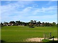
Pit Field/Three Acres/Crossway Field
The name of the fields according to Hurstpierpoint's 1842 tithe map that have been joined together to make a larger unit. Pit Field was in the foreground adjacent to New Way Lane whilst Crossway Field lay on the far side next to the parish boundary with Clayton. Three Acres lay in the middle. The geology here is one of greensand and thus the ridge was used to quarry sand, originally a small pit north of Image but during the 20th century a much larger pit was begun from the eastern side, an extension from the Stonepound Pit near the crossroads of the same name in Hassocks, which eventually extended up to New Way Lane. By the 1970s it was used as a refuse tip and since then has been returned to pasture.
Image: © Simon Carey
Taken: 22 Jun 2014
0.04 miles
3
Bearstakes, New Way Lane
The house dates from the 16th century and lies on the eastern side of the lane.
Image: © Simon Carey
Taken: 22 Jun 2014
0.06 miles
4
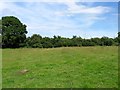
Dog Kennel Field/Banky Field/Middle Part
The name of the fields according to Hurspierpoint's 1842 tithe map that have been join together to make a larger unit. Dog Kennel Field lay in the foreground to the south of Image whilst Banky Field has largely disappeared under the houses in the distance, the actual bank leading up to them giving an idea where it was once located. Middle Part lay to the east on the right. The old Roman road linking Pevensey to Hardham once ran through this field.
Image: © Simon Carey
Taken: 7 Jun 2014
0.09 miles
5
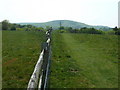
Agger, Sussex Greensand Way
The agger of an old Roman road is still visible here prior to it running through the hedge that marks the course of New Way Lane, a 16th century highway. The road originally ran from Hardham from a junction with Stane Street to Barcombe Mills. The earthworks are located in Image
Image: © Simon Carey
Taken: 22 Jun 2014
0.09 miles
6

Sandy Field
The name of the field according to Hurstpierpoint's 1842 tithe map that has also been known as Sandhills in the past as it occupies a small ridge of greensand. The field is bounded by New Way Lane to the east, Danny Park to the south, Image to the west and Image to the north
Image: © Simon Carey
Taken: 22 Jun 2014
0.10 miles
7
Looking south along path on the Danny Estate
Among the trees is Danny Lake and Wolstonbury Hill is beyond.
Image: © Dave Spicer
Taken: 30 Apr 2011
0.12 miles
8
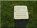
Information post regarding Roman Road
To the right the road continues in a WSW direction but on the left within a few yards the road turns and runs due east.
Image: © Dave Spicer
Taken: 30 Apr 2011
0.13 miles
9

Cutler's Brook
Viewed from New Way Lane prior to it joining Danny Lake. The stream is a tributary of the River Adur.
Image: © Simon Carey
Taken: 22 Jun 2014
0.15 miles
10
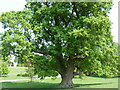
Ancient Oak tree at Danny park
This fine specimen has a girth of 7.5 metres, nearby is another Oak of 10.5 metres. Unfortunately I didn't see that one.
Image: © Dave Spicer
Taken: 30 Apr 2011
0.15 miles