IMAGES TAKEN NEAR TO
Hammonds Mill Place, BN6 9AW
Introduction
This page details the photographs taken nearby to Hammonds Mill Place, BN6 9AW by members of the Geograph project.
The Geograph project started in 2005 with the aim of publishing, organising and preserving representative images for every square kilometre of Great Britain, Ireland and the Isle of Man.

There are currently over 7.5m images from over14,400 individuals and you can help contribute to the project by visiting https://www.geograph.org.uk
Image Map
Images are licensed for reuse under creativecommons.org/licenses/by-sa/2.0
Notes
- Clicking on the map will re-center to the selected point.
- The higher the marker number, the further away the image location is from the centre of the postcode.
Image Listing (35 Images Found)
Images are licensed for reuse under creativecommons.org/licenses/by-sa/2.0
Image
Details
Distance
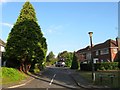
1
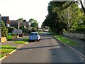
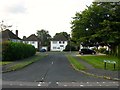
Spinney Close, Hurstpierpoint
Built in the early 1960s as a cul de sac but later extended through to Highfield Drive. This view looks up towards its junction with Wickham Drive. Prior to building it was a field called Little Knowles according to Hurstpierpoint's 1842 tithe map.
Image: © Simon Carey
Taken: 7 Aug 2014
0.05 miles
2
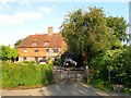
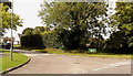
Wickham Farmhouse, College Lane, Hurst Wickham
The farmhouse dates from the 17th century and was originally the only building on College Lane between the hamlet of Hurst Wickham and Hassocks Road, now the B2116.
Image: © Simon Carey
Taken: 7 Aug 2014
0.06 miles
3
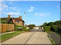
Wickham Drive, Hurstpierpoint
Originally built as a drive from College Lane to Wickham Place a house built in 1926 and now part of an estate that was built around it during the 1960s.
Image: © Simon Carey
Taken: 7 Aug 2014
0.06 miles
4
Lynton Close, Hurstpierpoint
Small cul de sac off College Lane built in the 1950s on a former field called Home Mead, according to Hurstpierpoint's 1842 tithe map. Named after a nearby house located on the corner of Hassocks road and College Lane which was demolished to make way for Image
Image: © Simon Carey
Taken: 7 Aug 2014
0.07 miles
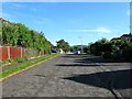
5
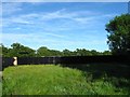
Flat Mead
The name of the field according to Hurspierpoint's 1842 tithe map which lies behind the large fence which may suggest some future development is on the way. The field lies to the south of Image off College Lane.
Image: © Simon Carey
Taken: 7 Jun 2014
0.08 miles
7
Pine Tree Close, Hurstpierpoint
A small cul de sac off Highfield Drive built in the 1960s.
Image: © Simon Carey
Taken: 7 Aug 2014
0.09 miles
8
Cherrington Close, Hurstpierpoint
A small cul de sac off Highfield Drive built in the 1960s.
Image: © Simon Carey
Taken: 7 Aug 2014
0.11 miles
9
Wolstonbury Close, Hurstpierpoint
A small cul de sac off College Lane that was built on the site of a Victorian house called Lynton which is commemorated by Image which lies to the north. Prior to the house being built it was a field called The Mead according to Hurstpierpoint's 1842 tithe map.
Image: © Simon Carey
Taken: 7 Aug 2014
0.12 miles
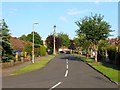
10
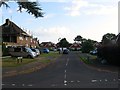
Highfield Drive, Hurstpierpoint
Built in the late 1950s/early 1960s on what was originally a field called Great Knowles according to Hurstpierpoint's 1842 tithe map, and later became the grounds of Wickham Place, a house built in 1926, which still exists in the centre of the estate.
Image: © Simon Carey
Taken: 7 Jun 2014
0.12 miles