IMAGES TAKEN NEAR TO
North End, HASSOCKS, BN6 8TE
Introduction
This page details the photographs taken nearby to North End, BN6 8TE by members of the Geograph project.
The Geograph project started in 2005 with the aim of publishing, organising and preserving representative images for every square kilometre of Great Britain, Ireland and the Isle of Man.

There are currently over 7.5m images from over14,400 individuals and you can help contribute to the project by visiting https://www.geograph.org.uk
Image Map
Images are licensed for reuse under creativecommons.org/licenses/by-sa/2.0
Notes
- Clicking on the map will re-center to the selected point.
- The higher the marker number, the further away the image location is from the centre of the postcode.
Image Listing (44 Images Found)
Images are licensed for reuse under creativecommons.org/licenses/by-sa/2.0
Image
Details
Distance
1
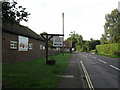
Turner Dumbrell Workshops
Viewed from North End, the B2112, the former outbuildings of North End Farm have been converted into local craft workshops run by the Turner Dumbrell Trust. See link for some of the tenants http://www.turnerdumbrellworkshops.co.uk/tenants.htm
Image: © Simon Carey
Taken: 19 Aug 2009
0.06 miles
2
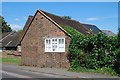
Old Toll House by the B2112, Ditchling
Toll House by the B2112 (North End), in parish of Ditchling (Lewes District), the small building by Turner Workshops.
Surveyed
Milestone Society National ID: ES.DIT
Image: © Milestone Society
Taken: Unknown
0.07 miles
3
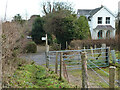
Permissive path from Lodge Hill reaches the B2112, Ditchling
Image: © Robin Webster
Taken: 14 Dec 2010
0.08 miles
4
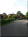
Dumbrells Court
Small development built on the former site of North End Farm.
Image: © Simon Carey
Taken: 19 Aug 2009
0.10 miles
5
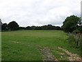
Further Bowries
The name of the field according to the 1843 tithe map and named after a nearby house.
Image: © Simon Carey
Taken: 16 Aug 2009
0.10 miles
6
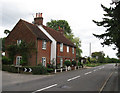
Cottages, North End
On the northern edge of the village of Ditchling beyond them the road becomes Common Lane. Numbered 1 to 3 only the middle cottage has name, Lavender Cottage.
Image: © Simon Carey
Taken: 16 Aug 2009
0.10 miles
7
Private farmland, Ditchling
It is, however, bordered on the left by a permissive path from Lodge Hill to the B2112.
Image: © Robin Webster
Taken: 14 Dec 2010
0.10 miles
8
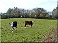
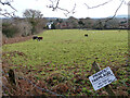
Cattle, Ditchling
In a field between the B2112 and Lodge Hill.
Image: © Robin Webster
Taken: 14 Dec 2010
0.12 miles
9
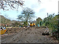
Garden groundworks off Lodge Hill Lane, 2010
Access to dig a swimming pool seems likely.
Image: © Robin Webster
Taken: 14 Dec 2010
0.12 miles
10
Barn Field
The name of the field according to the 1843 tithe map. Viewed from Lodge Hill Lane on the eastern side of Lodge Hill. The rooftops at the end of the field belong to houses in North End, the B2112.
Image: © Simon Carey
Taken: 19 Aug 2009
0.12 miles