IMAGES TAKEN NEAR TO
East Gardens, HASSOCKS, BN6 8ST
Introduction
This page details the photographs taken nearby to East Gardens, BN6 8ST by members of the Geograph project.
The Geograph project started in 2005 with the aim of publishing, organising and preserving representative images for every square kilometre of Great Britain, Ireland and the Isle of Man.

There are currently over 7.5m images from over14,400 individuals and you can help contribute to the project by visiting https://www.geograph.org.uk
Image Map (Loading...)


Getting Data...Please wait
Leaflet Map data © OpenStreetMap
Images are licensed for reuse under creativecommons.org/licenses/by-sa/2.0
Notes
- Clicking on the map will re-center to the selected point.
- The higher the marker number, the further away the image location is from the centre of the postcode.
Image Listing (245 Images Found)
Images are licensed for reuse under creativecommons.org/licenses/by-sa/2.0
Image
Details
Distance
1

Public footpath, Ditchling
This public footpath leads northwards from the village of Ditchling in the South Downs National Park.
Image: © Malc McDonald
Taken: 26 May 2013
0.03 miles
2

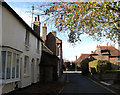
High Street, Ditchling, East Sussex
View taken looking S down the High Street of this small village. The S Downs are visible in the background. The flags were out because this was the day that the Tour de France came to town.
Image: © Pete Chapman
Taken: 6 Jul 1994
0.05 miles
3

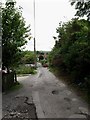
The Sussex Border Path leaving the High Street and turning into East Gardens
Image: © Dave Spicer
Taken: 6 Feb 2010
0.05 miles
4

North End
The name of the B2112 as it heads north out of Ditchling.
Image: © Simon Carey
Taken: 16 Aug 2009
0.06 miles
5

Dycheling Antiques, High Street
Jutting out into the road at the junction with East End Lane. The latter is the ancient eastern route out of the village prior to Lewes Road.
Image: © Simon Carey
Taken: 10 Nov 2007
0.06 miles
6
The Dymmocks
Name of the road in view after a former field of the same name. It links East Gardens with East End Lane.
Image: © Simon Carey
Taken: 16 Aug 2009
0.06 miles
7
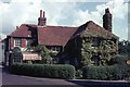
East End Lane
Looking back towards the junction with High Street. The lane was the original main street of Ditchling until medieval times when it realigned along the present High Street. However, it still remained the eastern route out of the village until that was superseded by a new turnpike in 1810 that is now the current B2116. The window on the left marks the location of the former post office that is now based at the village crossroads.
Image: © Simon Carey
Taken: 4 Nov 2009
0.06 miles
8

The North Star, North End
A former public house on the B2112 as it heads north out of the village. It closed a number of years ago and is now a private residence.
Image: © Simon Carey
Taken: 16 Aug 2009
0.07 miles

10
Wood's The Butcher
At the time this photo was taken at the corner of East End Lane, the striped awning protected the wares on display in the window of Mr Wood the butcher, who also had premises at Alfriston and Burgess Hill.
Image: © Peter Jeffery
Taken: Unknown
0.07 miles