IMAGES TAKEN NEAR TO
Lodge Hill Lane, HASSOCKS, BN6 8SR
Introduction
This page details the photographs taken nearby to Lodge Hill Lane, BN6 8SR by members of the Geograph project.
The Geograph project started in 2005 with the aim of publishing, organising and preserving representative images for every square kilometre of Great Britain, Ireland and the Isle of Man.

There are currently over 7.5m images from over14,400 individuals and you can help contribute to the project by visiting https://www.geograph.org.uk
Image Map
Images are licensed for reuse under creativecommons.org/licenses/by-sa/2.0
Notes
- Clicking on the map will re-center to the selected point.
- The higher the marker number, the further away the image location is from the centre of the postcode.
Image Listing (36 Images Found)
Images are licensed for reuse under creativecommons.org/licenses/by-sa/2.0
Image
Details
Distance
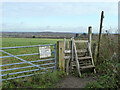
1
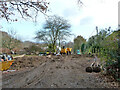
Garden groundworks off Lodge Hill Lane, 2010
Access to dig a swimming pool seems likely.
Image: © Robin Webster
Taken: 14 Dec 2010
0.02 miles
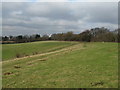
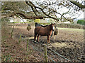
3
Lodge Hill Coppice
The name of the field according to the 1843 tithe map which gives its use as pasture suggesting the wood that may have existed here had already gone then. Oldlands Mill is visible in the distance to the left.
Image: © Simon Carey
Taken: 19 Aug 2009
0.06 miles
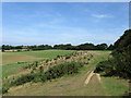
7
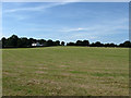
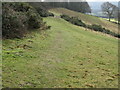
Lower West
The name of the field according to the 1843 tithe map. This view of the field looks up the slope of Lodge Hill.
Image: © Simon Carey
Taken: 19 Aug 2009
0.08 miles
8
Barn Field
The name of the field according to the 1843 tithe map. Viewed from Lodge Hill Lane on the eastern side of Lodge Hill. The rooftops at the end of the field belong to houses in North End, the B2112.
Image: © Simon Carey
Taken: 19 Aug 2009
0.10 miles
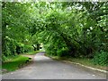
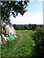
10
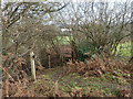
Start of permissive path from Lodge Hill to B2112, Ditchling
Image: © Robin Webster
Taken: 14 Dec 2010
0.12 miles