IMAGES TAKEN NEAR TO
Streat Lane, HASSOCKS, BN6 8RT
Introduction
This page details the photographs taken nearby to Streat Lane, BN6 8RT by members of the Geograph project.
The Geograph project started in 2005 with the aim of publishing, organising and preserving representative images for every square kilometre of Great Britain, Ireland and the Isle of Man.

There are currently over 7.5m images from over14,400 individuals and you can help contribute to the project by visiting https://www.geograph.org.uk
Image Map
Images are licensed for reuse under creativecommons.org/licenses/by-sa/2.0
Notes
- Clicking on the map will re-center to the selected point.
- The higher the marker number, the further away the image location is from the centre of the postcode.
Image Listing (138 Images Found)
Images are licensed for reuse under creativecommons.org/licenses/by-sa/2.0
Image
Details
Distance
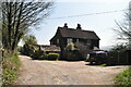
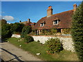
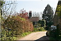
4
Cottages along side bridleway at Streat
Image: © Dave Spicer
Taken: 20 May 2009
0.03 miles
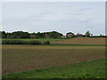
10
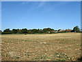
South Field
The name of the field according to the 1838 tithe map. The field climbs up the small ridge which contains part of the small village of Streat.
Image: © Simon Carey
Taken: 26 Sep 2009
0.06 miles