IMAGES TAKEN NEAR TO
The Oaks, Henfield Road, HENFIELD, BN5 9XU
Introduction
This page details the photographs taken nearby to The Oaks, Henfield Road, BN5 9XU by members of the Geograph project.
The Geograph project started in 2005 with the aim of publishing, organising and preserving representative images for every square kilometre of Great Britain, Ireland and the Isle of Man.

There are currently over 7.5m images from over14,400 individuals and you can help contribute to the project by visiting https://www.geograph.org.uk
Image Map
Images are licensed for reuse under creativecommons.org/licenses/by-sa/2.0
Notes
- Clicking on the map will re-center to the selected point.
- The higher the marker number, the further away the image location is from the centre of the postcode.
Image Listing (23 Images Found)
Images are licensed for reuse under creativecommons.org/licenses/by-sa/2.0
Image
Details
Distance
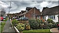
1
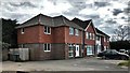
Building at the corner of Sands Lane and the A2037
Image: © Ian Hawfinch
Taken: 2 Apr 2020
0.01 miles
3
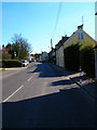
Henfield Road, Small Dole
The A2037 forming part of the village street. Taken from outside the post office with the village pub, The Fox, at the end of the terrace. The village has grown since the war having been little more than a few cottages scattered along the road from Henfield to Upper Beeding.
Image: © Simon Carey
Taken: 8 Apr 2008
0.03 miles
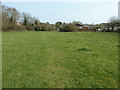
5
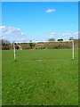
Small Dole Sports Ground
Squeezed between the main road and Tottington Wood is the village football ground.
Image: © Simon Carey
Taken: 8 Apr 2008
0.07 miles
7
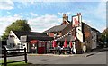
The Fox public house, Small Dole, West Sussex
Image: © nick macneill
Taken: 31 Aug 2012
0.09 miles
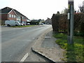
8
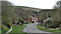
Approaching Small Dole from the north on the A2037
Image: © Ian Hawfinch
Taken: 2 Apr 2020
0.09 miles
9

Pond, Tottington Wood
The wood is a local nature reserve to the south east of Small Dole and has been open to access since 1992.
Image: © Simon Carey
Taken: 8 Apr 2008
0.12 miles
10
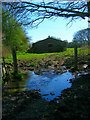
Outbuilding near Small Dole
Taken from the footpath that runs from the village to the River Adur.
Image: © Simon Carey
Taken: 8 Apr 2008
0.13 miles