IMAGES TAKEN NEAR TO
Broomfield Road, HENFIELD, BN5 9UZ
Introduction
This page details the photographs taken nearby to Broomfield Road, BN5 9UZ by members of the Geograph project.
The Geograph project started in 2005 with the aim of publishing, organising and preserving representative images for every square kilometre of Great Britain, Ireland and the Isle of Man.

There are currently over 7.5m images from over14,400 individuals and you can help contribute to the project by visiting https://www.geograph.org.uk
Image Map
Images are licensed for reuse under creativecommons.org/licenses/by-sa/2.0
Notes
- Clicking on the map will re-center to the selected point.
- The higher the marker number, the further away the image location is from the centre of the postcode.
Image Listing (245 Images Found)
Images are licensed for reuse under creativecommons.org/licenses/by-sa/2.0
Image
Details
Distance
1
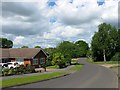
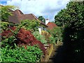
Broomfield Road, Henfield
The southern end of the road was constructed in the 1860s and originally turned west to rejoin Lower Station Road, see Image The northern portion was added in the early 1970s and now terminates at the junction with Upper Station Road.
Image: © Simon Carey
Taken: 14 May 2017
0.03 miles
2
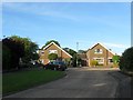
Broomfield Gardens, Henfield
A cul de sac off Broomfield Road that was built in the late 1960s.
Image: © Simon Carey
Taken: 21 May 2017
0.03 miles
3
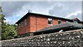
Rear of Red Oaks Care Home from a Henfield twitten
Henfield has an exceptionally high density of public footpaths running through it. Many of them might be described as "twittens" in the local parlance because they are narrow ways between buildings or gardens.
Image: © Ian Hawfinch
Taken: 24 Aug 2020
0.03 miles
4
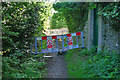
Southern Gas Networks block the footpath
There were no official notices posted for this blockage. Fortunately there is a deviation route available to the left just behind the viewpoint, completing a small triangle with this path and Broomfield Road beyond the far barriers ahead.
Image: © Robin Webster
Taken: 25 Sep 2010
0.04 miles
5
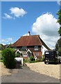
Wannock, School Lane, Henfield
The name of the house on the left which appears to date from the 19th century but was extended after the Second World War. The roof beyond belongs to Fox Cottage. School Lane is a footpath that runs from Church Lane to The Hooks and was named after a former girls school that was located to the south.
Image: © Simon Carey
Taken: 14 May 2017
0.04 miles
7
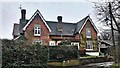
Walders Cottage/Oak Cottage, Church Lane, Henfield
Originally a single cottage dating from the 19th century that was converted into a pair of dwellings in 2016. Located at the point where Church Lane becomes School Lane, the latter a footpath that heads south to The Hooks.
Image: © Simon Carey
Taken: 14 May 2017
0.05 miles
9
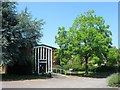
Corpus Christi Catholic Church, Henfield
The current building dates from 1974 and was constructed to replace an older wooden church that had been erected in 1929 in the grounds of Red Oaks.
Image: © Simon Carey
Taken: 9 Jul 2017
0.06 miles
10
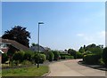
Squire Way, Henfield
A small residential road that connects Croft Lane to Broomfield Road. It was built in the 1970s on the site of Broomfields that had been built in 1860s as a large house with a purpose built doctor's surgery attahed to the side. The house was demolished in 1971.
Image: © Simon Carey
Taken: 9 Jul 2017
0.06 miles