IMAGES TAKEN NEAR TO
Broomfield Road, HENFIELD, BN5 9UA
Introduction
This page details the photographs taken nearby to Broomfield Road, BN5 9UA by members of the Geograph project.
The Geograph project started in 2005 with the aim of publishing, organising and preserving representative images for every square kilometre of Great Britain, Ireland and the Isle of Man.

There are currently over 7.5m images from over14,400 individuals and you can help contribute to the project by visiting https://www.geograph.org.uk
Image Map
Images are licensed for reuse under creativecommons.org/licenses/by-sa/2.0
Notes
- Clicking on the map will re-center to the selected point.
- The higher the marker number, the further away the image location is from the centre of the postcode.
Image Listing (202 Images Found)
Images are licensed for reuse under creativecommons.org/licenses/by-sa/2.0
Image
Details
Distance
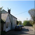
1
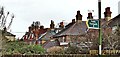
Henfield, Sussex - rear view of houses on Broomfields Road
Image: © Ian Hawfinch
Taken: 8 Feb 2020
0.01 miles
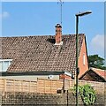
2
Henfield, Sussex - rear view of houses on Broomfield Road
Storm Ciara (yesterday) has caused one of these fence panels to come adrift.
Image: © Ian Hawfinch
Taken: 10 Feb 2020
0.02 miles
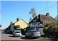
3
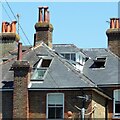
Hot day in Henfield
The open skylights tell a story. This house is on Broomfield Road.
Image: © Ian Hawfinch
Taken: 18 Jul 2021
0.03 miles
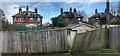
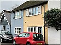
4

Broomfield Road, Henfield
A residential road that links Nep Town Road to Upper Station Road. Originally the road swung west at the former Broomfield House to rejoin Lower Station Road. The northern extension was added after the war. The road was laid out in the late 19th century with a few Victorian semi-detached villas visible through the trees to the left. Much of the rest of the road was developed after the Second World War.
Image: © Simon Carey
Taken: 9 Apr 2017
0.03 miles
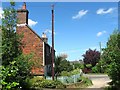
6
The Forge/1-2 Mill End Cottage, Mill End, Nep Town, Henfield
All buildings appear to date from the 19th century with the building on the left once having been a forge that was converted into light industrial use. The planning page for the building also notes that it has been used as a shop and the last application in 2014 was to convert it into a residence. Nep Town Road becomes Mill End at the junction with Broomfield Road before turning into Dropping Holms at the junction with Sandy Lane. The short section of road contains these buildings and neighbouring Image
Image: © Simon Carey
Taken: 9 Apr 2017
0.04 miles
7
Wistaria Cottage, Mill End, Nep Town, Henfield
Located to the immediate east of Image and also built in the 17th century. The spelling is that taken from the name plate outside the house. Beyond is Image
Image: © Simon Carey
Taken: 9 Apr 2017
0.04 miles
9
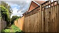
Public footpath leading from Mill End to The Hooks
This might be described as a "twitten". See also Image
Image: © Ian Hawfinch
Taken: 24 Aug 2020
0.04 miles
10
Rosemount, Windmill Lane, Nep Town, Henfield
An 18th century building located at the junction with Mill End.
Image: © Simon Carey
Taken: 10 Jun 2017
0.05 miles