1
Henfield House, Croft Lane, Henfield
Located at the northern end of Croft Lane. Built in the 1860s and originally known as Broomfield Villa and later Broomfield House. The South Downs can be seen in the distance and probably gives some idea of the excellent views from the southern side of the house.
Image: © Simon Carey
Taken: 9 Jul 2017
0.02 miles
2
Squire Way, Henfield
A small residential road that connects Croft Lane to Broomfield Road. It was built in the 1970s on the site of Broomfields that had been built in 1860s as a large house with a purpose built doctor's surgery attahed to the side. The house was demolished in 1971.
Image: © Simon Carey
Taken: 9 Jul 2017
0.03 miles
3
Evening scene - Broomfield Road
Image: © Ian Hawfinch
Taken: 29 Jul 2022
0.04 miles
4
Broomfield Road, Henfield
The original section of the road that was developed in the 1860s that ran north from Nep Town Road then turned west to Lower Station Road. During the early 1970s the road was extended northwards, see
Image, with this portion reduced to little more than a footpath that now contains
Image at the western end.
Image: © Simon Carey
Taken: 14 May 2017
0.04 miles
5
Southern Gas Networks block the footpath
There were no official notices posted for this blockage. Fortunately there is a deviation route available to the left just behind the viewpoint, completing a small triangle with this path and Broomfield Road beyond the far barriers ahead.
Image: © Robin Webster
Taken: 25 Sep 2010
0.05 miles
6
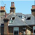
Hot day in Henfield
The open skylights tell a story. This house is on Broomfield Road.
Image: © Ian Hawfinch
Taken: 18 Jul 2021
0.05 miles
7
Henfield, Sussex - view northwards from Sandy Lane
There were plans to build houses on the field in the foreground, but I think they have been shelved.
Image: © Ian Hawfinch
Taken: 4 Feb 2020
0.06 miles
8
Broomfield Road, Henfield
A residential road that links Nep Town Road to Upper Station Road. Originally the road swung west at the former Broomfield House to rejoin Lower Station Road. The northern extension was added after the war. The road was laid out in the late 19th century with a few Victorian semi-detached villas visible through the trees to the left. Much of the rest of the road was developed after the Second World War.
Image: © Simon Carey
Taken: 9 Apr 2017
0.06 miles
9
Public Footpath descending to Broomfield Lane
This path goes from the end of Croft Lane to Broomfield Lane. Roofs of houses in Batts Drive can be seen below.
Image: © Peter Holmes
Taken: 18 Mar 2008
0.06 miles
10
Modern Houses, Batts Pond Lane
With a view over Batts Pond. The track also serves a footpath that heads towards the village centre.
Image: © Simon Carey
Taken: 28 Oct 2008
0.06 miles


