IMAGES TAKEN NEAR TO
Fabians Way, HENFIELD, BN5 9PT
Introduction
This page details the photographs taken nearby to Fabians Way, BN5 9PT by members of the Geograph project.
The Geograph project started in 2005 with the aim of publishing, organising and preserving representative images for every square kilometre of Great Britain, Ireland and the Isle of Man.

There are currently over 7.5m images from over14,400 individuals and you can help contribute to the project by visiting https://www.geograph.org.uk
Image Map
Images are licensed for reuse under creativecommons.org/licenses/by-sa/2.0
Notes
- Clicking on the map will re-center to the selected point.
- The higher the marker number, the further away the image location is from the centre of the postcode.
Image Listing (109 Images Found)
Images are licensed for reuse under creativecommons.org/licenses/by-sa/2.0
Image
Details
Distance
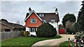
1
Flower Farm Close, Henfield
A cul de sac off Fabians Way that was constructed in the early 1960s on the site of a former nursery that specialised in flowers. For much of the 20th century Henfield was the centre of a large market garden industry supplying nearby Brighton and whilst a few nurseries remain most have now been developed or have been vacated.
Image: © Simon Carey
Taken: 1 Jun 2017
0.04 miles
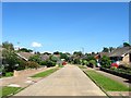
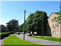
2
Fabians Way, Henfield
A residential road running north from Upper Station Road that was built during the 1960s. The road provides access to both Henfield's primary school and its leisure centre.
Image: © Simon Carey
Taken: 18 Apr 2017
0.06 miles
3
St Peter's Church of England Primary School, Fabians Way, Henfield
The school opened in 1957 initially as an addition to Image before replacing it fully in the mid 1980s. The building itself has undergone a number of expansions to accommodate the growing population of the village. After completing their education here pupils transfer to either Downlands in Hassocks or Steyning Grammar School.
Image: © Simon Carey
Taken: 1 Jun 2017
0.06 miles
4
Gresham Place, Henfield
A cul de sac off Staples Barn built around 1960.
Image: © Simon Carey
Taken: 9 Jul 2017
0.06 miles
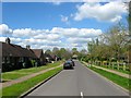
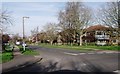
5
Northcroft, Henfield
A residential road heading east from Fabians Way before changing to Image as it heads north towards Image The road was built in the early 1970s.
Image: © Simon Carey
Taken: 1 Jun 2017
0.09 miles
6
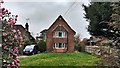
House on Upper Station Road
The unusual symmetrical frontage attracted my attention.
Image: © Ian Hawfinch
Taken: 7 Mar 2020
0.09 miles
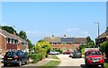
9
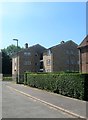
26-28, Staples Barn, Henfield
A small block of flats that are part of the Staples Barn estate built sometime in the 1960s.
Image: © Simon Carey
Taken: 9 Jul 2017
0.11 miles
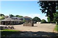
10
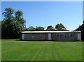
The Eric Holder Pavilion, Kings Field, Henfield
Built in the late 1980s to accommodate a flourishing local football team, Henfield FC, whose emphasis is on youth. Located on the southern side of the playing field.
Image: © Simon Carey
Taken: 1 Jun 2017
0.11 miles