IMAGES TAKEN NEAR TO
Upper Station Road, HENFIELD, BN5 9PH
Introduction
This page details the photographs taken nearby to Upper Station Road, BN5 9PH by members of the Geograph project.
The Geograph project started in 2005 with the aim of publishing, organising and preserving representative images for every square kilometre of Great Britain, Ireland and the Isle of Man.

There are currently over 7.5m images from over14,400 individuals and you can help contribute to the project by visiting https://www.geograph.org.uk
Image Map
Images are licensed for reuse under creativecommons.org/licenses/by-sa/2.0
Notes
- Clicking on the map will re-center to the selected point.
- The higher the marker number, the further away the image location is from the centre of the postcode.
Image Listing (174 Images Found)
Images are licensed for reuse under creativecommons.org/licenses/by-sa/2.0
Image
Details
Distance
1
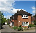
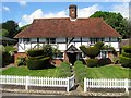
Hacketts End, Hacketts Lane, Henfield
A 19th century cottage located at the junction with Upper Station Road.
Image: © Simon Carey
Taken: 18 Apr 2017
0.03 miles
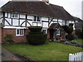
2
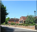
The Hacketts, Upper Station Road, Henfield
I believe the house to have been converted from an outbuilding once belong to neighbouring Image
Image: © Simon Carey
Taken: 9 Jul 2017
0.05 miles
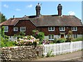
3
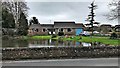
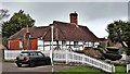
House on the corner of Broomfield Road
This house/bungalow is situated on the corner of Broomfield Road, where it meets Upper Station Road. It has an exceptionally large pond in its front garden - so large that I imagine it was there before the house was built.
Image: © Ian Hawfinch
Taken: 7 Mar 2020
0.05 miles
4
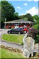
Parish Hall, Church Lane, Henfield
A parish room occupied this site from the first decade of the 20th century and was rebuilt during the early 1970s.
Image: © Simon Carey
Taken: 14 May 2017
0.05 miles
5
Apple Tree Cottage, Church Lane, Henfield
Originally a single hall house dating possibly as far back as the 14th century though extensively refurbished during the Tudor period. Located opposite the church yard.
Image: © Simon Carey
Taken: 14 May 2017
0.05 miles
7
Hacketts, Church Lane, Henfield
The building dates from the late 16th century and appears to have been subdivided and rejoined on a number of occasions over the centuries, the last fairly recently when the owner of Hacketts on the left purchased what was known as Duffies to the right to return the building to a single dwelling. Located to the immediate south of the church yard.
Image: © Simon Carey
Taken: 14 May 2017
0.07 miles
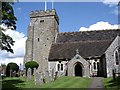
9
Henfield, Sussex - house near the church
Image: © Ian Hawfinch
Taken: 10 Feb 2020
0.07 miles
10
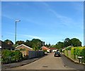
Knowles Close, Henfield
A cul de sac off Broomfield Road that was built in the late 1970s in the grounds of Henfield Place. The tower of St Peter's Church is just visible behind the trees.
Image: © Simon Carey
Taken: 21 May 2017
0.07 miles