IMAGES TAKEN NEAR TO
Church Lane, HENFIELD, BN5 9NY
Introduction
This page details the photographs taken nearby to Church Lane, BN5 9NY by members of the Geograph project.
The Geograph project started in 2005 with the aim of publishing, organising and preserving representative images for every square kilometre of Great Britain, Ireland and the Isle of Man.

There are currently over 7.5m images from over14,400 individuals and you can help contribute to the project by visiting https://www.geograph.org.uk
Image Map
Images are licensed for reuse under creativecommons.org/licenses/by-sa/2.0
Notes
- Clicking on the map will re-center to the selected point.
- The higher the marker number, the further away the image location is from the centre of the postcode.
Image Listing (296 Images Found)
Images are licensed for reuse under creativecommons.org/licenses/by-sa/2.0
Image
Details
Distance
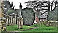
1
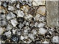
Henfield - St Peter's Church
Often ancient buildings were made with the local materials: flint and sandstone make a wonderful pattern in the walls of St Peter's, the highest geographical point in Henfield.
Image: © Francois Thomas
Taken: 17 Apr 2005
0.02 miles
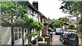
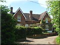
2
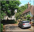
2-3, Church Lane, Henfield
A pair of 19th century cottages to the south of the church. Beyond is the junction of Church Lane and Tan Yard.
Image: © Simon Carey
Taken: 14 May 2017
0.02 miles
4
Red Oak Cottages, Tan Yard, Henfield
A pair of cottages built in the late 19th century.
Image: © Simon Carey
Taken: 14 May 2017
0.02 miles
5
Henfield, Sussex - churchyard and cottages
Image: © Ian Hawfinch
Taken: 9 Feb 2020
0.02 miles
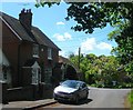
7
Walders Cottage/Oak Cottage, Church Lane, Henfield
Originally a single cottage dating from the 19th century that was converted into a pair of dwellings in 2016. Located at the point where Church Lane becomes School Lane, the latter a footpath that heads south to The Hooks.
Image: © Simon Carey
Taken: 14 May 2017
0.03 miles
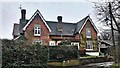
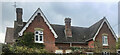
8
Old Tudor Cottage, Church Lane, Henfield
Located to the south of the church and dating from the late 16th century.
Image: © Simon Carey
Taken: 14 May 2017
0.03 miles
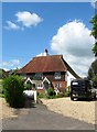
9
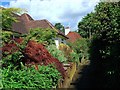
Wannock, School Lane, Henfield
The name of the house on the left which appears to date from the 19th century but was extended after the Second World War. The roof beyond belongs to Fox Cottage. School Lane is a footpath that runs from Church Lane to The Hooks and was named after a former girls school that was located to the south.
Image: © Simon Carey
Taken: 14 May 2017
0.03 miles