1
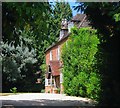
Parsonage House, Parsonage Road, Henfield
Built in the 16th century, rebuilt in the 17th and refronted around 1820. Originally home to the prebendaries of Henfield and later Thomas Bysshop a Postmaster General for Charles II who invented the postmark. By the 19th century it was a farmhouse whose outbuildings survived until the 1970s when they were demolished to make way for Parsonage Road.
Image: © Simon Carey
Taken: 9 Jul 2017
0.01 miles
2
House at the junction of Parsonage Road and Church Street
Image: © Ian Hawfinch
Taken: 13 Feb 2020
0.01 miles
3
Rear view of houses on Church Terrace, Henfield
Image: © Ian Hawfinch
Taken: 13 Feb 2020
0.02 miles
4
Rear view of houses on Church Terrace, Henfield
Image: © Ian Hawfinch
Taken: 13 Feb 2020
0.02 miles
5
Sobell Court - and view towards the church
Image: © Ian Hawfinch
Taken: 5 Apr 2020
0.03 miles
6
Parsonage Road, Henfield
A residential road that runs between Church Street and London Road, the A281, that was built in the late 1970s. These houses are located near the junction with the former.
Image: © Simon Carey
Taken: 21 May 2017
0.04 miles
7
Farm Close, Henfield
A cul de sac off Parsonage Road built in the latter part of the 1970s though Parsonage Farm Cottages, beyond the hedge and out of shot to the left, predate its construction having been erected in the early 1950s.
Image: © Simon Carey
Taken: 9 Jul 2017
0.04 miles
8
Sobell Court, Church Street, Henfield
Sheltered housing off Church Street that was built in 1973.
Image: © Simon Carey
Taken: 18 Apr 2017
0.04 miles
9
Henfield churchyard
There are many of these curiously trimmed shrubs lining the paths in the churchyard.
Image: © Robin Webster
Taken: 25 Sep 2010
0.05 miles
10
Hacketts, Church Lane, Henfield
The building dates from the late 16th century and appears to have been subdivided and rejoined on a number of occasions over the centuries, the last fairly recently when the owner of Hacketts on the left purchased what was known as Duffies to the right to return the building to a single dwelling. Located to the immediate south of the church yard.
Image: © Simon Carey
Taken: 14 May 2017
0.05 miles


