IMAGES TAKEN NEAR TO
Clappers Lane, HENFIELD, BN5 9NJ
Introduction
This page details the photographs taken nearby to Clappers Lane, BN5 9NJ by members of the Geograph project.
The Geograph project started in 2005 with the aim of publishing, organising and preserving representative images for every square kilometre of Great Britain, Ireland and the Isle of Man.

There are currently over 7.5m images from over14,400 individuals and you can help contribute to the project by visiting https://www.geograph.org.uk
Image Map
Images are licensed for reuse under creativecommons.org/licenses/by-sa/2.0
Notes
- Clicking on the map will re-center to the selected point.
- The higher the marker number, the further away the image location is from the centre of the postcode.
Image Listing (8 Images Found)
Images are licensed for reuse under creativecommons.org/licenses/by-sa/2.0
Image
Details
Distance
1
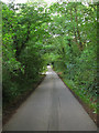
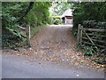
Clappers Lane
Single track country lane linking Fulking to the A281. This section is of some antiquity as it forms the parish boundary between Poynings on the right and Fulking to the left (pre 1894 it was Edburton). The light on the left indicates turnings for Badger Wood Farm.
Image: © Simon Carey
Taken: 16 Aug 2010
0.04 miles
3
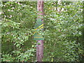
Homemade road sign
Unfortunate choice of colour made it difficult to see
Image: © Dave Spicer
Taken: 3 Oct 2009
0.12 miles
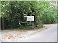
5
Entrance to Timbers
This is a timber clad house
Image: © Dave Spicer
Taken: 3 Oct 2009
0.15 miles
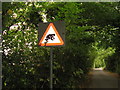
6
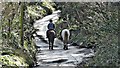
Horse riders on Clappers Lane
The white on the lane is reflected light - not frost or snow.
Image: © Ian Hawfinch
Taken: 12 Mar 2020
0.20 miles
7
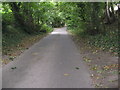
Clappers Lane heading north towards the A281
Image: © Dave Spicer
Taken: 3 Oct 2009
0.20 miles
8
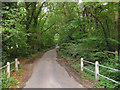
Clappers Lane
Viewed from the junction with Holmbush Lane. The single track lane heads south to Fulking and is an old droving route of some antiquity with it forming the parish boundary between Poynings on the left and Fulking (Formerly Edburton) on the right.
Image: © Simon Carey
Taken: 16 Aug 2010
0.24 miles