IMAGES TAKEN NEAR TO
Edburton Road, HENFIELD, BN5 9LS
Introduction
This page details the photographs taken nearby to Edburton Road, BN5 9LS by members of the Geograph project.
The Geograph project started in 2005 with the aim of publishing, organising and preserving representative images for every square kilometre of Great Britain, Ireland and the Isle of Man.

There are currently over 7.5m images from over14,400 individuals and you can help contribute to the project by visiting https://www.geograph.org.uk
Image Map
Images are licensed for reuse under creativecommons.org/licenses/by-sa/2.0
Notes
- Clicking on the map will re-center to the selected point.
- The higher the marker number, the further away the image location is from the centre of the postcode.
Image Listing (24 Images Found)
Images are licensed for reuse under creativecommons.org/licenses/by-sa/2.0
Image
Details
Distance
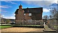
1
Perching Sands Farmhouse
A stone marker in the centre of the house gives the date as 1846. The footpath from Nettledown follows the drive then heads south to Fulking.
Image: © Simon Carey
Taken: 7 Nov 2008
0.03 miles
2
Side view of Perching Sands farmhouse
This is the north side - the front faces east, and has the date '1853' on it. The public footpath goes right past the front of the house, so the obvious thing would have been to take a photo of the front - but I felt slightly uncomfortable doing that, hence the sly side-shot! I don't know why I felt that way - after all it's a compliment to the house that I wanted to photograph it. I guess it just seemed a bit 'full-on' because the path is so close and there's nothing between you and the house.
Image: © Ian Hawfinch
Taken: 12 Mar 2020
0.05 miles
3
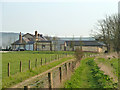
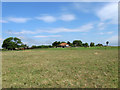
Perching Sands Farm
With the South Downs beyond.
Image: © Robin Webster
Taken: 25 Mar 2011
0.08 miles
4
Buildings to the north of Perching Sands farmhouse
This is a cross-grid telephoto shot. The camera was in TQ2312. I think the building on the left is recently built, and contains stables. The Devil's Dyke pub can be seen on the top of the Downs, to the right of the clump of trees.
Image: © Ian Hawfinch
Taken: 12 Mar 2020
0.08 miles
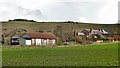
5
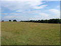
The Taint Sands (1)
The name of the field according to the 1842 tithe map. Perching Sands Farm lies at the top of the small hillock.
Image: © Simon Carey
Taken: 16 Aug 2010
0.09 miles
6
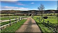
View south down the track leading to Perching Sands Farm
Perching Sands Farm Cottages can be seen in the distance. This track is also a public footpath. Another footpath crosses it about 100m north of the cottages.
Image: © Ian Hawfinch
Taken: 12 Mar 2020
0.11 miles
7
The Taint Sands (2)
The name of the field according to the 1842 tithe map that is bisected by Perching Drove. The field also contains the footpath to Clappers Lane.
Image: © Simon Carey
Taken: 16 Aug 2010
0.11 miles
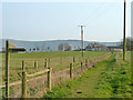
8
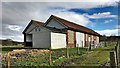
Stables north of Perching Sands farmhouse
The public footpath is just off the right-hand side of the photo - to the right of the fence. I think these stables are relatively new - I don't see them in other, earlier images for this square. Also they're not on the 1 : 25 000 OS map as far as I can see.
Image: © Ian Hawfinch
Taken: 12 Mar 2020
0.12 miles
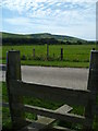
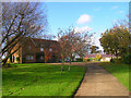
10
Footpath towards Perching Sands Farm
Image: © Robin Webster
Taken: 25 Mar 2011
0.15 miles