IMAGES TAKEN NEAR TO
Nep Town Road, HENFIELD, BN5 9EA
Introduction
This page details the photographs taken nearby to Nep Town Road, BN5 9EA by members of the Geograph project.
The Geograph project started in 2005 with the aim of publishing, organising and preserving representative images for every square kilometre of Great Britain, Ireland and the Isle of Man.

There are currently over 7.5m images from over14,400 individuals and you can help contribute to the project by visiting https://www.geograph.org.uk
Image Map
Images are licensed for reuse under creativecommons.org/licenses/by-sa/2.0
Notes
- Clicking on the map will re-center to the selected point.
- The higher the marker number, the further away the image location is from the centre of the postcode.
Image Listing (283 Images Found)
Images are licensed for reuse under creativecommons.org/licenses/by-sa/2.0
Image
Details
Distance
1
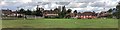
View across Rothery Field towards Nep Town Road
The football pitch here is quite well used - it even has floodlights. A public footpath cuts diagonally across it.
Image: © Ian Hawfinch
Taken: 28 Aug 2020
0.00 miles
3
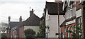
Henfield, Sussex - cottages overlooking Rothery Field
Image: © Ian Hawfinch
Taken: 10 Feb 2020
0.01 miles
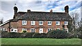
5
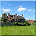
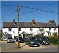
Cedar View, Nep Town Road, Nep Town, Henfield
Originally built as a workhouse in 1736 and remained so until Henfield became part of Steyning Union in the 1830s. By the end of the century it had been converted into four cottages. Viewed from Image which had once been the workhouse's own field.
Image: © Simon Carey
Taken: 10 Jun 2017
0.01 miles
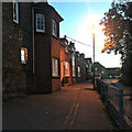
6
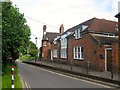
The Old School House, Nep Town Road, Nep Town, Henfield
Opened in 1844 as an infants school continuing in operation until the 1960s. It subsequently was used as a youth club until sold around 2003 after which it was converted into two dwellings. A new youth club building was erected in King's Field, see Image
Image: © Simon Carey
Taken: 10 Jun 2017
0.01 miles
8
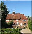
Tudor Cottage, Nep Town Road, Nep Town, Henfield
Originally a timber framed building from the 17th century that has been refronted with bricks. This is the eastern side of a semi-detached building that also includes Rapley Cottage.
Image: © Simon Carey
Taken: 9 Apr 2017
0.02 miles
10
Hedgecocks Cottages, Nep Town Road, Nep Town
Not marked on Henfield's 1844 tithe map but do appear on the 1875-76 OS map which will give some idea of when this terrace was constructed.
Image: © Simon Carey
Taken: 9 Apr 2017
0.02 miles