IMAGES TAKEN NEAR TO
Wheatsheaf Road, HENFIELD, BN5 9BA
Introduction
This page details the photographs taken nearby to Wheatsheaf Road, BN5 9BA by members of the Geograph project.
The Geograph project started in 2005 with the aim of publishing, organising and preserving representative images for every square kilometre of Great Britain, Ireland and the Isle of Man.

There are currently over 7.5m images from over14,400 individuals and you can help contribute to the project by visiting https://www.geograph.org.uk
Image Map
Images are licensed for reuse under creativecommons.org/licenses/by-sa/2.0
Notes
- Clicking on the map will re-center to the selected point.
- The higher the marker number, the further away the image location is from the centre of the postcode.
Image Listing (24 Images Found)
Images are licensed for reuse under creativecommons.org/licenses/by-sa/2.0
Image
Details
Distance
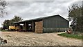
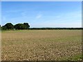
1
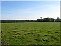
The Four Acres
The name of the field according to Woodmancote's 1839 tithe map that is bounded by Image to the north, Image to the west, Woodhouse Farm to the east and Woodhouse holiday Cottages to the south.
All of the land between the A23 and Henfield is currently threatened with a proposed private development to build a new garden town the size of Burgess Hill.
Image: © Simon Carey
Taken: 21 Aug 2014
0.06 miles
4
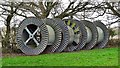
Giant reels in a field
This is my second photograph of these reels, but from a different angle - showing the words 'ILJIN Electric' stamped on the side of the first reel. A bit of googling reveals them to be a Korean based company specialising the manufacture of electrical transmission equipment, including power cables.
Image: © Ian Hawfinch
Taken: 14 Feb 2020
0.10 miles
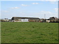
7
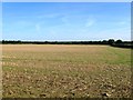
Blind Lane Field
The name of the field according to Woodmancote's 1839 tithe map that has been merged with Image to the west to form a larger unit. It is bounded by Image to the south, Image to the north and Image to the east. The blind lane in question may have been a track leading to Woodhouse.
All of the land between the A23 and Henfield is currently threatened with a proposed private development to build a new garden town the size of Burgess Hill.
Image: © Simon Carey
Taken: 21 Aug 2014
0.11 miles
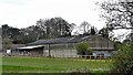
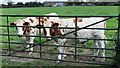
9
Gate Field
The name of the field according to Woodmancote's 1839 tithe map that has been merged with Image to the east to form a larger unit. To the north is Image and to the south is Image
All of the land between the A23 and Henfield is currently threatened with a proposed private development to build a new garden town the size of Burgess Hill.
Image: © Simon Carey
Taken: 21 Aug 2014
0.12 miles
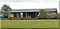
10
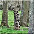
Owl wood sculpture near Woodhouse Farm
Image: © Ian Hawfinch
Taken: 28 Mar 2020
0.13 miles