1
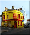
Three Jolly Butchers
Is at the corner of Frederick St and North Rd. I like the unusual sign.
Image: © Mike White
Taken: 4 May 2009
0.01 miles
2
Three Jolly Butchers pub sign
I like the cryptic subtlety of this sign. Pity it's in poor shape.
Image: © Mike White
Taken: 2 May 2009
0.01 miles
3
Royal Mail Sorting Office
Located in North Road and built in 1926 on the site of the former Regent Iron Foundry that operated on the site from 1810 to 1912.
Image: © Simon Carey
Taken: 25 Sep 2011
0.01 miles
4
Frederick Gardens, BN1 (2)
Image: © Mike Quinn
Taken: 8 May 2012
0.02 miles
5
Royal Mail building on North Road, Brighton
Image: © Ian S
Taken: 24 Jan 2016
0.02 miles
6
The Foundry, Foundry Street, Brighton
Originally the White Horse in the 1850s but became the Pedestrian Arms sometime in the latter half of the 19th, a name it retained until fairly recently. Both pub and street name recall the former Regent Foundry which operated from 1810 to 1912 and whose site is now occupied by the Royal Mail sorting office.
Image: © Simon Carey
Taken: 1 Nov 2015
0.02 miles
7
Foundry Street
A side street linking North Road to Gloucester Road and named after the former foundry that once lay beyond the buildings on the left that was originally built on open fields and eventually got engulfed by the northern expansion of Brighton in the 1840s. The foundry produced many works which still stand today including the original railings along much of the sea front. It was closed in the 1920s, demolished and replaced by a new Royal Mail sorting office which still stands today.
Image: © Simon Carey
Taken: 31 Jul 2011
0.03 miles
8
Frederick Street, BN1 (2)
Image: © Mike Quinn
Taken: 8 May 2012
0.03 miles
9
Frederick Gardens
Head south down Over Street then by The Pond a small alleyway continues in the same direction. This is Frederick Gardens whose workers cottages were built in the 1820s most likely for the Iron Foundry which used to be in the southern side of the alley. More on this in the next picture. The ugly building behind it is Gresham House built on the site of a former theatre which was destroyed by fire in 1961.
Click on the link to take you to the next page. http://www.geograph.org.uk/photo/230632
Image: © Simon Carey
Taken: 1 Sep 2006
0.03 miles
10
66, North Road, Brighton
Located on the corner of Foundry Street and currently occupied by Drum Cavern. As can be seen by the stone work this was once the Dolphin Inn which opened in the 1840s and closed in 1971. See http://brightonmuseums.org.uk/brighton/what-to-see/views-of-brighton-hove-in-the-early-19th-century/works-on-show/?cblid=BTNRP_BH421065
Image: © Simon Carey
Taken: 25 Oct 2015
0.03 miles


