IMAGES TAKEN NEAR TO
Henfield Road, BRIGHTON, BN45 7AZ
Introduction
This page details the photographs taken nearby to Henfield Road, BN45 7AZ by members of the Geograph project.
The Geograph project started in 2005 with the aim of publishing, organising and preserving representative images for every square kilometre of Great Britain, Ireland and the Isle of Man.

There are currently over 7.5m images from over14,400 individuals and you can help contribute to the project by visiting https://www.geograph.org.uk
Image Map
Images are licensed for reuse under creativecommons.org/licenses/by-sa/2.0
Notes
- Clicking on the map will re-center to the selected point.
- The higher the marker number, the further away the image location is from the centre of the postcode.
Image Listing (19 Images Found)
Images are licensed for reuse under creativecommons.org/licenses/by-sa/2.0
Image
Details
Distance
1
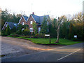
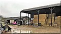
Poynings Cat Boarding Hotel
Based in Grange Farm Cottage next to Henfield Road, the A281. The entrance is also a private drive for nearby Poynings Grange Farm.
Image: © Simon Carey
Taken: 7 Nov 2008
0.00 miles
2
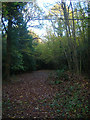
Park Wood
Ancient woodland once belonging to nearby Newtimber Place. It is currently split between the Scouts who own the northern part and the southern portion which is in private hands. This access track is for the southern part of the wood from the A281.
Image: © Simon Carey
Taken: 7 Nov 2008
0.06 miles
3
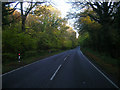
Henfield Road, Park Wood
The A281 runs through the wood. This was one of the original London-Brighton roads running via Devil's Dyke through Henfield and Horsham then onto the capital.
Image: © Simon Carey
Taken: 7 Nov 2008
0.09 miles
4
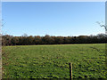
Varn Croft
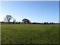
The name of the field according to the 1840 tithe map. According to the same map the wood at the end of the field was called Varn Crofts Wood though on today's A to Z West Sussex map it is marked as Barncroft Copse. Somewhere along the line the V has become a B unless of course the person collecting information for the map got his information wrong having to spell from what some local Sussex yokel was telling him. Quite easy to do as nearby Locks Green in TQ2616 was written down as Lops Green and the field name Laine was written down as Laying. All done by the same 19th century mapmaker.
Image: © Simon Carey
Taken: 1 Jan 2010
0.13 miles
5
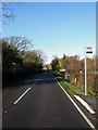
Bus Stops, Henfield Road
On the A281 outside Rushfields Nursery.
Image: © Simon Carey
Taken: 28 Dec 2009
0.19 miles
6
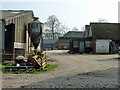
Farmyard, Poynings Grange Farm
Distinguished by a completely silent and inanimate dog in front of the green door. Sleeping dogs...?
Image: © Robin Webster
Taken: 25 Mar 2011
0.20 miles
7
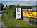
Rushfields Garden Centre
On the Henfield Road at Poynings
Image: © Nigel Freeman
Taken: 11 Aug 2005
0.20 miles
9
The Compts
The name of the field according to the 1840 tithe map which has been expanded to include part of Faggot Stack Field to the south though the trees and some of the hedgerow still exists to show where the separation once occurred.
Image: © Simon Carey
Taken: 1 Jan 2010
0.21 miles
10
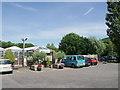
Entrance to Rushfields Garden Centre, Poynings
Image: © nick macneill
Taken: 30 Jun 2010
0.21 miles