IMAGES TAKEN NEAR TO
Poynings Road, BRIGHTON, BN45 7AN
Introduction
This page details the photographs taken nearby to Poynings Road, BN45 7AN by members of the Geograph project.
The Geograph project started in 2005 with the aim of publishing, organising and preserving representative images for every square kilometre of Great Britain, Ireland and the Isle of Man.

There are currently over 7.5m images from over14,400 individuals and you can help contribute to the project by visiting https://www.geograph.org.uk
Image Map
Images are licensed for reuse under creativecommons.org/licenses/by-sa/2.0
Notes
- Clicking on the map will re-center to the selected point.
- The higher the marker number, the further away the image location is from the centre of the postcode.
Image Listing (39 Images Found)
Images are licensed for reuse under creativecommons.org/licenses/by-sa/2.0
Image
Details
Distance
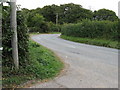
1
Poynings Grange Cottages
On Poynings Road at the junction of the bridleway that leads to Poynings Grange Farm.
Image: © Simon Carey
Taken: 7 Nov 2008
0.01 miles
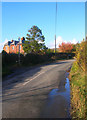
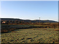
3
Northern approach road into Poynings
Grange Lodge Cottages are just around the bend.
Image: © Dave Spicer
Taken: 6 Feb 2011
0.04 miles
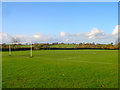
4
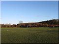
Poynings Recreation Ground
Containing a football pitch with a small playground to the south located in what was once Mill Field according to the 1840 tithe map. A separate cricket field lies over the road.
Image: © Simon Carey
Taken: 1 Jan 2010
0.04 miles
5
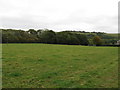
View across field to Cobsham Rough
Just visible on the right are Grange Lodge Cottages and Newtimber Hill in the background
Image: © Dave Spicer
Taken: 3 Oct 2009
0.05 miles
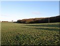
6
Pond Field
The name of the field according to the 1840 tithe map. There may be no pond now but a small stream runs through the middle of it. Behind from left to right are Fulking Hill, Perching Hill, Edburton Hill and Truleigh Hill.
Image: © Simon Carey
Taken: 1 Jan 2010
0.05 miles
7
Poynings Recreation Ground
On Poynings Road at the northern end of the village. There is also a separate cricket ground on the other side of the road.
Image: © Simon Carey
Taken: 7 Nov 2008
0.07 miles
8
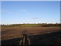
The Plat
The name of this section of the field according to the 1840 tithe map that has been extended westwards to include Sheepwash Field. Viewed from a gap in the hedge at the western end of Poynings Recreation Ground as can be seen by my shadow.
Image: © Simon Carey
Taken: 1 Jan 2010
0.08 miles
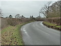
9
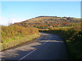
Poynings Road
Linking the A281 with the village. Newtimber Hill is in the background.
Image: © Simon Carey
Taken: 7 Nov 2008
0.10 miles
10
Touts
The name of the field according to the 1840 tithe map. Viewed from the bridleway to Poynings Grange Farm with Cobsham Rough to the right.
Image: © Simon Carey
Taken: 1 Jan 2010
0.11 miles