IMAGES TAKEN NEAR TO
The Florets, Hyde Street, STEYNING, BN44 3TY
Introduction
This page details the photographs taken nearby to The Florets, Hyde Street, BN44 3TY by members of the Geograph project.
The Geograph project started in 2005 with the aim of publishing, organising and preserving representative images for every square kilometre of Great Britain, Ireland and the Isle of Man.

There are currently over 7.5m images from over14,400 individuals and you can help contribute to the project by visiting https://www.geograph.org.uk
Image Map
Images are licensed for reuse under creativecommons.org/licenses/by-sa/2.0
Notes
- Clicking on the map will re-center to the selected point.
- The higher the marker number, the further away the image location is from the centre of the postcode.
Image Listing (49 Images Found)
Images are licensed for reuse under creativecommons.org/licenses/by-sa/2.0
Image
Details
Distance
1
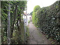
Twitten to Hyde Lane
Public footpath 2784 from New Road.
Image: © Peter Holmes
Taken: 28 Sep 2013
0.03 miles
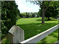
2
Path to Manor Road
Public footpath from Hyde Street.
Image: © Peter Holmes
Taken: 28 Sep 2013
0.04 miles
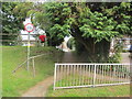
3
Open land on Hyde Street in Upper Beeding
Windmill Hill forms the skyline.
Image: © Shazz
Taken: 24 Jun 2011
0.05 miles
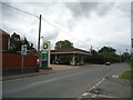
6
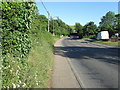
Henfield Road, Upper Beeding
Looking east up the A2037 from the Rising Sun Inn
Image: © Chris Heaton
Taken: 10 May 2011
0.07 miles
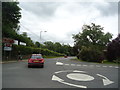
9
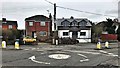
Roundabout at the junction between Hyde Lane and Bramber High Street
Image: © Ian Hawfinch
Taken: 9 Mar 2020
0.08 miles
10
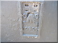
Ordnance Survey Flush Bracket 10306
This Bracket can be found on a wall of the Rising Sun PH.
For more details see : http://www.bench-marks.org.uk/bm13000
Image: © Peter Wood
Taken: 1 Apr 2012
0.08 miles